You are here: Home > Network List > GS - US Geological Survey Networks Stations List
> Station KAN13 Rinehart Farm > Earthquake Result Viewer
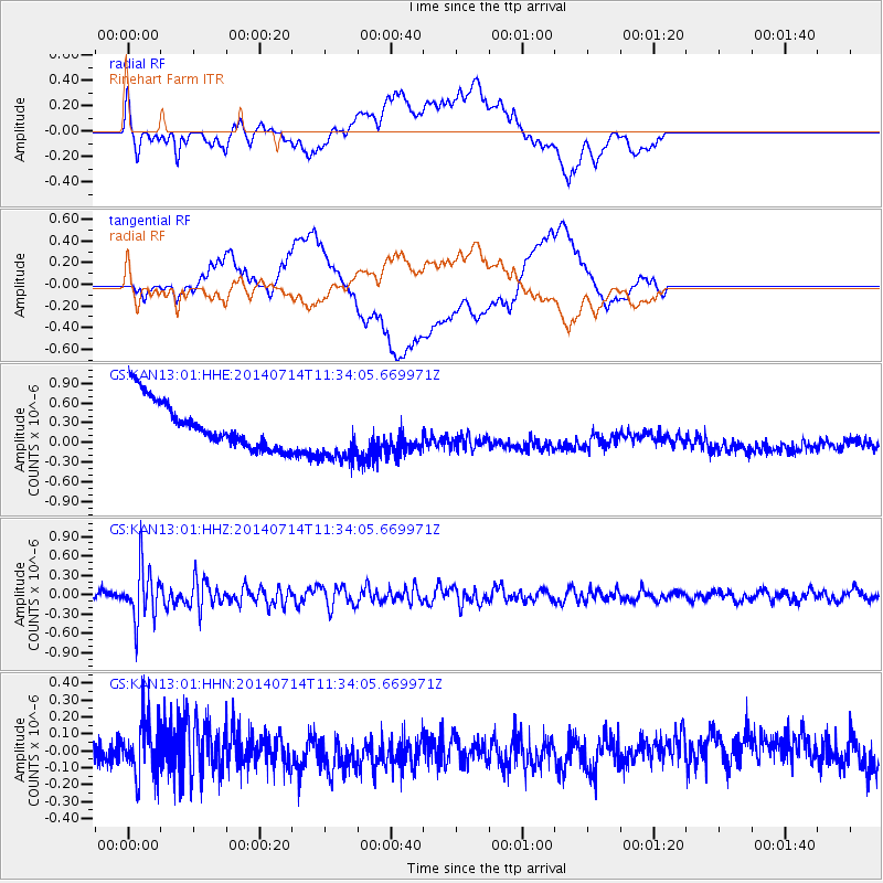
KAN13 Rinehart Farm - Earthquake Result Viewer
*The percent match for this event was below the threshold and hence no stack was calculated.
| Earthquake location: |
Off Coast Of Peru |
| Earthquake latitude/longitude: |
-17.9/-73.4 |
| Earthquake time(UTC): |
2014/07/14 (195) 11:24:39 GMT |
| Earthquake Depth: |
33 km |
| Earthquake Magnitude: |
5.5 M |
| Earthquake Catalog/Contributor: |
NEIC PDE/NEIC ALERT |
|
| Network: |
GS US Geological Survey Networks |
| Station: |
KAN13 Rinehart Farm |
| Lat/Lon: |
37.01 N/97.48 W |
| Elevation: |
340 m |
|
| Distance: |
59.2 deg |
| Az: |
337.665 deg |
| Baz: |
153.127 deg |
| Ray Param: |
$rayparam |
*The percent match for this event was below the threshold and hence was not used in the summary stack. |
|
| Radial Match: |
34.42527 % |
| Radial Bump: |
400 |
| Transverse Match: |
23.899609 % |
| Transverse Bump: |
400 |
| SOD ConfigId: |
3390531 |
| Insert Time: |
2019-04-12 20:54:14.840 +0000 |
| GWidth: |
2.5 |
| Max Bumps: |
400 |
| Tol: |
0.001 |
|
Signal To Noise
| Channel | StoN | STA | LTA |
| GS:KAN13:01:HHZ:20140714T11:34:05.669971Z | 6.0290093 | 4.1794354E-7 | 6.932209E-8 |
| GS:KAN13:01:HHN:20140714T11:34:05.669971Z | 3.1483932 | 1.6720243E-7 | 5.3107225E-8 |
| GS:KAN13:01:HHE:20140714T11:34:05.669971Z | 1.2887282 | 4.460722E-7 | 3.4613362E-7 |
| Arrivals |
| Ps | |
| PpPs | |
| PsPs/PpSs | |


