You are here: Home > Network List > GT - Global Telemetered Seismograph Network (USAF/USGS) Stations List
> Station SBA Scott Base, Antarctica > Earthquake Result Viewer
SBA Scott Base, Antarctica - Earthquake Result Viewer
| Earthquake location: |
South Of Fiji Islands |
| Earthquake latitude/longitude: |
-23.8/-179.9 |
| Earthquake time(UTC): |
1998/04/14 (104) 03:41:22 GMT |
| Earthquake Depth: |
499 km |
| Earthquake Magnitude: |
5.5 MB, 6.2 UNKNOWN, 6.1 MW |
| Earthquake Catalog/Contributor: |
WHDF/NEIC |
|
| Network: |
GT Global Telemetered Seismograph Network (USAF/USGS) |
| Station: |
SBA Scott Base, Antarctica |
| Lat/Lon: |
77.85 S/166.76 E |
| Elevation: |
20 m |
|
| Distance: |
54.5 deg |
| Az: |
183.452 deg |
| Baz: |
15.087 deg |
| Ray Param: |
0.0633732 |
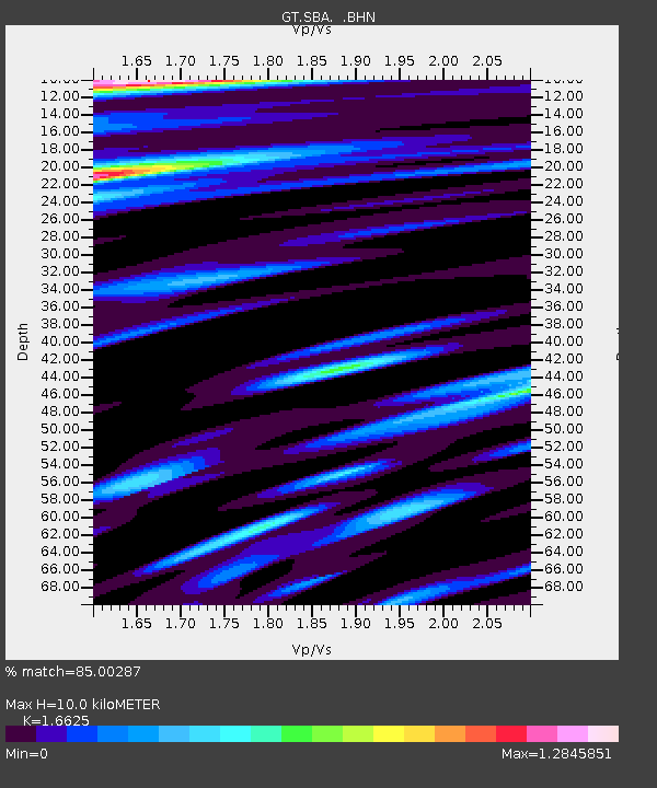
| Estimated Moho Depth: |
10.0 km |
| Estimated Crust Vp/Vs: |
1.66 |
| Assumed Crust Vp: |
6.183 km/s |
| Estimated Crust Vs: |
3.719 km/s |
| Estimated Crust Poisson's Ratio: |
0.22 |
|
| Radial Match: |
85.00287 % |
| Radial Bump: |
400 |
| Transverse Match: |
76.00934 % |
| Transverse Bump: |
400 |
| SOD ConfigId: |
4480 |
| Insert Time: |
2010-02-27 02:19:39.938 +0000 |
| GWidth: |
2.5 |
| Max Bumps: |
400 |
| Tol: |
0.001 |
|
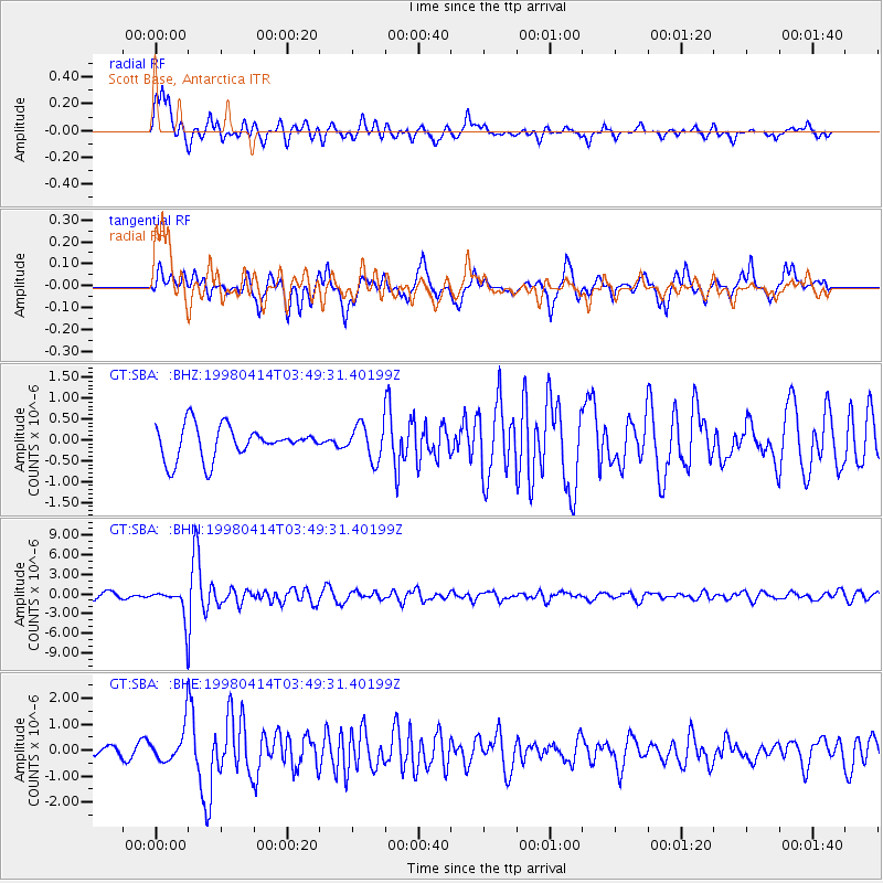
Signal To Noise
| Channel | StoN | STA | LTA |
| GT:SBA: :BHN:19980414T03:49:31.40199Z | 5.534219 | 2.3193638E-6 | 4.1909504E-7 |
| GT:SBA: :BHE:19980414T03:49:31.40199Z | 2.7327533 | 6.654485E-7 | 2.4350845E-7 |
| GT:SBA: :BHZ:19980414T03:49:31.40199Z | 1.0671269 | 4.1361034E-7 | 3.8759245E-7 |
| Arrivals |
| Ps | 1.1 SECOND |
| PpPs | 4.1 SECOND |
| PsPs/PpSs | 5.2 SECOND |


