You are here: Home > Network List > IU - Global Seismograph Network (GSN - IRIS/USGS) Stations List
> Station JOHN Johnston Island, USA > Earthquake Result Viewer
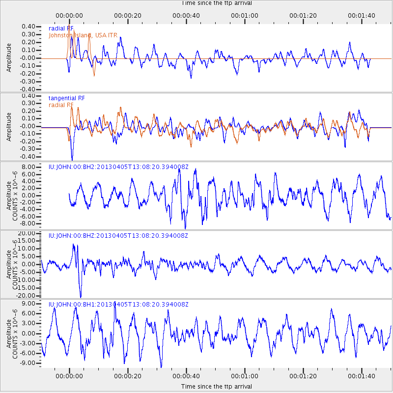
JOHN Johnston Island, USA - Earthquake Result Viewer
*The percent match for this event was below the threshold and hence no stack was calculated.
| Earthquake location: |
E. Russia-N.E. China Border Reg. |
| Earthquake latitude/longitude: |
42.7/131.0 |
| Earthquake time(UTC): |
2013/04/05 (095) 13:00:02 GMT |
| Earthquake Depth: |
563 km |
| Earthquake Magnitude: |
6.3 MW, 6.2 MB, 6.4 MW |
| Earthquake Catalog/Contributor: |
NEIC PDE/NEIC PDE-W |
|
| Network: |
IU Global Seismograph Network (GSN - IRIS/USGS) |
| Station: |
JOHN Johnston Island, USA |
| Lat/Lon: |
16.73 N/169.53 W |
| Elevation: |
2.0 m |
|
| Distance: |
56.5 deg |
| Az: |
98.159 deg |
| Baz: |
310.437 deg |
| Ray Param: |
$rayparam |
*The percent match for this event was below the threshold and hence was not used in the summary stack. |
|
| Radial Match: |
41.871464 % |
| Radial Bump: |
379 |
| Transverse Match: |
50.23844 % |
| Transverse Bump: |
400 |
| SOD ConfigId: |
512894 |
| Insert Time: |
2013-09-12 23:51:02.965 +0000 |
| GWidth: |
2.5 |
| Max Bumps: |
400 |
| Tol: |
0.001 |
|
Signal To Noise
| Channel | StoN | STA | LTA |
| IU:JOHN:00:BHZ:20130405T13:08:20.394008Z | 3.7740982 | 8.709074E-6 | 2.3075906E-6 |
| IU:JOHN:00:BH1:20130405T13:08:20.394008Z | 1.2912412 | 4.7754415E-6 | 3.698334E-6 |
| IU:JOHN:00:BH2:20130405T13:08:20.394008Z | 1.2344671 | 2.7350675E-6 | 2.2155855E-6 |
| Arrivals |
| Ps | |
| PpPs | |
| PsPs/PpSs | |


