You are here: Home > Network List > TA - USArray Transportable Network (new EarthScope stations) Stations List
> Station C36M Paulatuk, NT, CAN > Earthquake Result Viewer
C36M Paulatuk, NT, CAN - Earthquake Result Viewer
| Earthquake location: |
Mindanao, Philippines |
| Earthquake latitude/longitude: |
5.6/126.5 |
| Earthquake time(UTC): |
2014/07/14 (195) 08:40:54 GMT |
| Earthquake Depth: |
35 km |
| Earthquake Magnitude: |
4.9 mb |
| Earthquake Catalog/Contributor: |
ISC/ISC |
|
| Network: |
TA USArray Transportable Network (new EarthScope stations) |
| Station: |
C36M Paulatuk, NT, CAN |
| Lat/Lon: |
69.35 N/124.07 W |
| Elevation: |
10 m |
|
| Distance: |
91.5 deg |
| Az: |
19.555 deg |
| Baz: |
290.127 deg |
| Ray Param: |
0.04159074 |
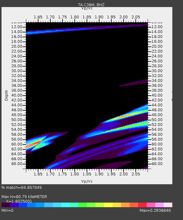
| Estimated Moho Depth: |
60.75 km |
| Estimated Crust Vp/Vs: |
1.60 |
| Assumed Crust Vp: |
6.459 km/s |
| Estimated Crust Vs: |
4.031 km/s |
| Estimated Crust Poisson's Ratio: |
0.18 |
|
| Radial Match: |
84.657845 % |
| Radial Bump: |
400 |
| Transverse Match: |
97.25326 % |
| Transverse Bump: |
315 |
| SOD ConfigId: |
3390531 |
| Insert Time: |
2019-04-12 21:02:42.498 +0000 |
| GWidth: |
2.5 |
| Max Bumps: |
400 |
| Tol: |
0.001 |
|

Signal To Noise
| Channel | StoN | STA | LTA |
| TA:C36M: :BHZ:20140714T08:53:25.674971Z | 1.6576991 | 8.6968663E-7 | 5.246348E-7 |
| TA:C36M: :BHN:20140714T08:53:25.674971Z | 1.9433348 | 3.9008867E-7 | 2.0073159E-7 |
| TA:C36M: :BHE:20140714T08:53:25.674971Z | 1.2726009 | 3.769551E-7 | 2.9620838E-7 |
| Arrivals |
| Ps | 5.8 SECOND |
| PpPs | 24 SECOND |
| PsPs/PpSs | 30 SECOND |


