You are here: Home > Network List > ZJ12 - Transantarctic Mountains Northern Network Stations List
> Station CASY East Antarctica > Earthquake Result Viewer
CASY East Antarctica - Earthquake Result Viewer
| Earthquake location: |
Minahassa Peninsula, Sulawesi |
| Earthquake latitude/longitude: |
-0.3/119.8 |
| Earthquake time(UTC): |
2014/07/15 (196) 02:38:00 GMT |
| Earthquake Depth: |
52 km |
| Earthquake Magnitude: |
4.9 MW, 5.0 mb |
| Earthquake Catalog/Contributor: |
ISC/ISC |
|
| Network: |
ZJ Transantarctic Mountains Northern Network |
| Station: |
CASY East Antarctica |
| Lat/Lon: |
73.30 S/159.63 E |
| Elevation: |
2223 m |
|
| Distance: |
76.8 deg |
| Az: |
169.03 deg |
| Baz: |
318.852 deg |
| Ray Param: |
0.050623536 |
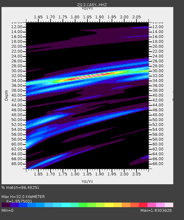
| Estimated Moho Depth: |
32.0 km |
| Estimated Crust Vp/Vs: |
1.86 |
| Assumed Crust Vp: |
6.306 km/s |
| Estimated Crust Vs: |
3.395 km/s |
| Estimated Crust Poisson's Ratio: |
0.30 |
|
| Radial Match: |
86.48251 % |
| Radial Bump: |
376 |
| Transverse Match: |
86.6445 % |
| Transverse Bump: |
311 |
| SOD ConfigId: |
3390531 |
| Insert Time: |
2019-04-12 21:16:11.950 +0000 |
| GWidth: |
2.5 |
| Max Bumps: |
400 |
| Tol: |
0.001 |
|

Signal To Noise
| Channel | StoN | STA | LTA |
| ZJ:CASY: :HHZ:20140715T02:49:15.679993Z | 0.49050903 | 5.393423E-7 | 1.0995564E-6 |
| ZJ:CASY: :HHN:20140715T02:49:15.679993Z | 1.277216 | 9.831928E-7 | 7.697937E-7 |
| ZJ:CASY: :HHE:20140715T02:49:15.679993Z | 0.50292516 | 7.2666774E-7 | 1.4448824E-6 |
| Arrivals |
| Ps | 4.5 SECOND |
| PpPs | 14 SECOND |
| PsPs/PpSs | 19 SECOND |


