You are here: Home > Network List > TA - USArray Transportable Network (new EarthScope stations) Stations List
> Station M39A Webster, IA, USA > Earthquake Result Viewer
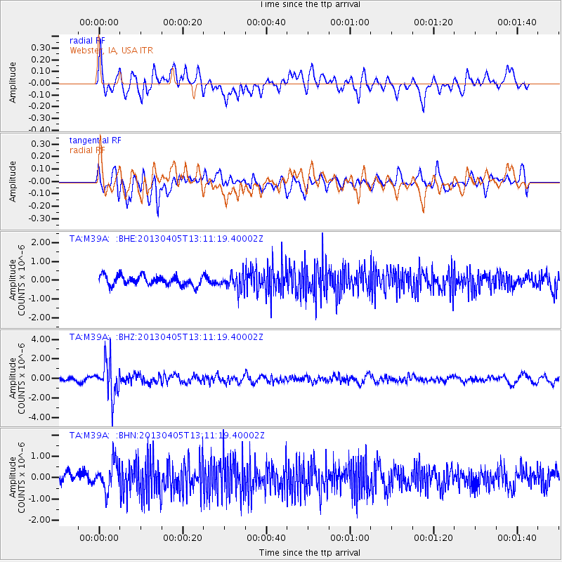
M39A Webster, IA, USA - Earthquake Result Viewer
*The percent match for this event was below the threshold and hence no stack was calculated.
| Earthquake location: |
E. Russia-N.E. China Border Reg. |
| Earthquake latitude/longitude: |
42.7/131.0 |
| Earthquake time(UTC): |
2013/04/05 (095) 13:00:02 GMT |
| Earthquake Depth: |
563 km |
| Earthquake Magnitude: |
6.3 MW, 6.2 MB, 6.4 MW |
| Earthquake Catalog/Contributor: |
NEIC PDE/NEIC PDE-W |
|
| Network: |
TA USArray Transportable Network (new EarthScope stations) |
| Station: |
M39A Webster, IA, USA |
| Lat/Lon: |
41.48 N/92.17 W |
| Elevation: |
264 m |
|
| Distance: |
87.6 deg |
| Az: |
30.971 deg |
| Baz: |
329.697 deg |
| Ray Param: |
$rayparam |
*The percent match for this event was below the threshold and hence was not used in the summary stack. |
|
| Radial Match: |
64.798325 % |
| Radial Bump: |
400 |
| Transverse Match: |
63.836533 % |
| Transverse Bump: |
400 |
| SOD ConfigId: |
512894 |
| Insert Time: |
2013-09-13 00:14:56.485 +0000 |
| GWidth: |
2.5 |
| Max Bumps: |
400 |
| Tol: |
0.001 |
|
Signal To Noise
| Channel | StoN | STA | LTA |
| TA:M39A: :BHZ:20130405T13:11:19.40002Z | 6.142532 | 1.7431464E-6 | 2.8378307E-7 |
| TA:M39A: :BHN:20130405T13:11:19.40002Z | 2.2428002 | 6.8286096E-7 | 3.0446805E-7 |
| TA:M39A: :BHE:20130405T13:11:19.40002Z | 1.6920459 | 4.3280747E-7 | 2.5578942E-7 |
| Arrivals |
| Ps | |
| PpPs | |
| PsPs/PpSs | |


