You are here: Home > Network List > TA - USArray Transportable Network (new EarthScope stations) Stations List
> Station N46A Monticello, IN, USA > Earthquake Result Viewer
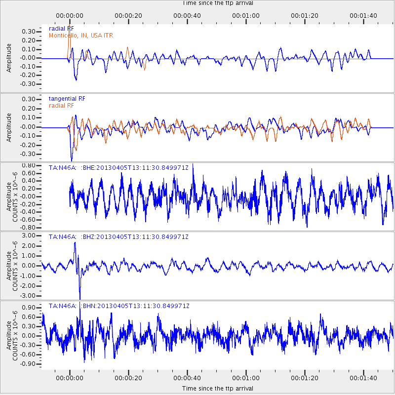
N46A Monticello, IN, USA - Earthquake Result Viewer
*The percent match for this event was below the threshold and hence no stack was calculated.
| Earthquake location: |
E. Russia-N.E. China Border Reg. |
| Earthquake latitude/longitude: |
42.7/131.0 |
| Earthquake time(UTC): |
2013/04/05 (095) 13:00:02 GMT |
| Earthquake Depth: |
563 km |
| Earthquake Magnitude: |
6.3 MW, 6.2 MB, 6.4 MW |
| Earthquake Catalog/Contributor: |
NEIC PDE/NEIC PDE-W |
|
| Network: |
TA USArray Transportable Network (new EarthScope stations) |
| Station: |
N46A Monticello, IN, USA |
| Lat/Lon: |
40.89 N/86.74 W |
| Elevation: |
209 m |
|
| Distance: |
90.0 deg |
| Az: |
27.645 deg |
| Baz: |
333.196 deg |
| Ray Param: |
$rayparam |
*The percent match for this event was below the threshold and hence was not used in the summary stack. |
|
| Radial Match: |
68.13801 % |
| Radial Bump: |
400 |
| Transverse Match: |
62.85709 % |
| Transverse Bump: |
400 |
| SOD ConfigId: |
512894 |
| Insert Time: |
2013-09-13 00:16:37.439 +0000 |
| GWidth: |
2.5 |
| Max Bumps: |
400 |
| Tol: |
0.001 |
|
Signal To Noise
| Channel | StoN | STA | LTA |
| TA:N46A: :BHZ:20130405T13:11:30.849971Z | 4.628633 | 1.1598011E-6 | 2.5057096E-7 |
| TA:N46A: :BHN:20130405T13:11:30.849971Z | 0.97648305 | 3.150709E-7 | 3.2265885E-7 |
| TA:N46A: :BHE:20130405T13:11:30.849971Z | 0.92560905 | 2.3680467E-7 | 2.558366E-7 |
| Arrivals |
| Ps | |
| PpPs | |
| PsPs/PpSs | |


