You are here: Home > Network List > YY13 - Exploring extensional tectonics beyond the Ethiopian Rift Stations List
> Station SERE Military Camp, Saraba, Ethiopia > Earthquake Result Viewer
SERE Military Camp, Saraba, Ethiopia - Earthquake Result Viewer
| Earthquake location: |
Mindanao, Philippines |
| Earthquake latitude/longitude: |
5.7/126.5 |
| Earthquake time(UTC): |
2014/07/14 (195) 07:59:58 GMT |
| Earthquake Depth: |
22 km |
| Earthquake Magnitude: |
6.4 MWP |
| Earthquake Catalog/Contributor: |
NEIC PDE/NEIC COMCAT |
|
| Network: |
YY Exploring extensional tectonics beyond the Ethiopian Rift |
| Station: |
SERE Military Camp, Saraba, Ethiopia |
| Lat/Lon: |
12.51 N/37.03 E |
| Elevation: |
2152 m |
|
| Distance: |
88.3 deg |
| Az: |
282.327 deg |
| Baz: |
84.579 deg |
| Ray Param: |
0.042664815 |
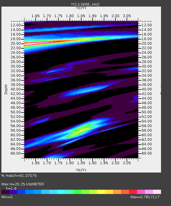
| Estimated Moho Depth: |
20.25 km |
| Estimated Crust Vp/Vs: |
1.60 |
| Assumed Crust Vp: |
6.464 km/s |
| Estimated Crust Vs: |
4.04 km/s |
| Estimated Crust Poisson's Ratio: |
0.18 |
|
| Radial Match: |
81.07075 % |
| Radial Bump: |
383 |
| Transverse Match: |
63.030445 % |
| Transverse Bump: |
400 |
| SOD ConfigId: |
3390531 |
| Insert Time: |
2019-04-12 21:19:51.333 +0000 |
| GWidth: |
2.5 |
| Max Bumps: |
400 |
| Tol: |
0.001 |
|

Signal To Noise
| Channel | StoN | STA | LTA |
| YY:SERE: :HHZ:20140714T08:12:15.559998Z | 3.4621046 | 3.0544666E-7 | 8.822571E-8 |
| YY:SERE: :HHN:20140714T08:12:15.559998Z | 1.5338405 | 1.0321756E-7 | 6.7293534E-8 |
| YY:SERE: :HHE:20140714T08:12:15.559998Z | 1.2976741 | 8.4617234E-8 | 6.520685E-8 |
| Arrivals |
| Ps | 1.9 SECOND |
| PpPs | 7.9 SECOND |
| PsPs/PpSs | 9.9 SECOND |


