You are here: Home > Network List > US - United States National Seismic Network Stations List
> Station HAWA Hanford, Washington, USA > Earthquake Result Viewer
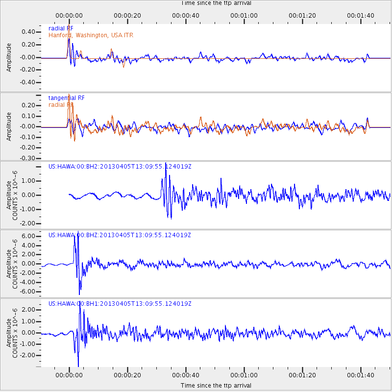
HAWA Hanford, Washington, USA - Earthquake Result Viewer
*The percent match for this event was below the threshold and hence no stack was calculated.
| Earthquake location: |
E. Russia-N.E. China Border Reg. |
| Earthquake latitude/longitude: |
42.7/131.0 |
| Earthquake time(UTC): |
2013/04/05 (095) 13:00:02 GMT |
| Earthquake Depth: |
563 km |
| Earthquake Magnitude: |
6.3 MW, 6.2 MB, 6.4 MW |
| Earthquake Catalog/Contributor: |
NEIC PDE/NEIC PDE-W |
|
| Network: |
US United States National Seismic Network |
| Station: |
HAWA Hanford, Washington, USA |
| Lat/Lon: |
46.39 N/119.53 W |
| Elevation: |
364 m |
|
| Distance: |
71.5 deg |
| Az: |
43.499 deg |
| Baz: |
312.886 deg |
| Ray Param: |
$rayparam |
*The percent match for this event was below the threshold and hence was not used in the summary stack. |
|
| Radial Match: |
63.172413 % |
| Radial Bump: |
400 |
| Transverse Match: |
59.103912 % |
| Transverse Bump: |
400 |
| SOD ConfigId: |
512894 |
| Insert Time: |
2013-09-13 00:26:44.067 +0000 |
| GWidth: |
2.5 |
| Max Bumps: |
400 |
| Tol: |
0.001 |
|
Signal To Noise
| Channel | StoN | STA | LTA |
| US:HAWA:00:BHZ:20130405T13:09:55.124019Z | 10.043947 | 2.9698758E-6 | 2.9568812E-7 |
| US:HAWA:00:BH1:20130405T13:09:55.124019Z | 7.48873 | 1.0072929E-6 | 1.3450784E-7 |
| US:HAWA:00:BH2:20130405T13:09:55.124019Z | 5.9033117 | 8.1273566E-7 | 1.3767453E-7 |
| Arrivals |
| Ps | |
| PpPs | |
| PsPs/PpSs | |


