You are here: Home > Network List > NM - Cooperative New Madrid Seismic Network Stations List
> Station HDAR2 I40 Weigh Station,West Memphis,AR > Earthquake Result Viewer
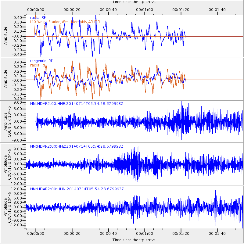
HDAR2 I40 Weigh Station,West Memphis,AR - Earthquake Result Viewer
*The percent match for this event was below the threshold and hence no stack was calculated.
| Earthquake location: |
Easter Island Region |
| Earthquake latitude/longitude: |
-26.7/-114.5 |
| Earthquake time(UTC): |
2014/07/14 (195) 05:44:16 GMT |
| Earthquake Depth: |
15 km |
| Earthquake Magnitude: |
5.5 MW, 5.4 mB, 5.3 Ms, 5.0 Ms7 |
| Earthquake Catalog/Contributor: |
ISC/ISC |
|
| Network: |
NM Cooperative New Madrid Seismic Network |
| Station: |
HDAR2 I40 Weigh Station,West Memphis,AR |
| Lat/Lon: |
35.15 N/90.09 W |
| Elevation: |
100 m |
|
| Distance: |
65.7 deg |
| Az: |
21.809 deg |
| Baz: |
203.928 deg |
| Ray Param: |
$rayparam |
*The percent match for this event was below the threshold and hence was not used in the summary stack. |
|
| Radial Match: |
55.83131 % |
| Radial Bump: |
400 |
| Transverse Match: |
67.66636 % |
| Transverse Bump: |
400 |
| SOD ConfigId: |
3390531 |
| Insert Time: |
2019-04-12 21:23:53.757 +0000 |
| GWidth: |
2.5 |
| Max Bumps: |
400 |
| Tol: |
0.001 |
|
Signal To Noise
| Channel | StoN | STA | LTA |
| NM:HDAR2:00:HHZ:20140714T05:54:28.679993Z | 0.6148199 | 1.0458543E-6 | 1.7010744E-6 |
| NM:HDAR2:00:HHN:20140714T05:54:28.679993Z | 1.0482866 | 1.2230281E-6 | 1.1666925E-6 |
| NM:HDAR2:00:HHE:20140714T05:54:28.679993Z | 0.6584908 | 9.864887E-7 | 1.4981055E-6 |
| Arrivals |
| Ps | |
| PpPs | |
| PsPs/PpSs | |


