You are here: Home > Network List > UW - Pacific Northwest Regional Seismic Network Stations List
> Station HOOD Mt Hood Meadows, OR CREST BB SMO > Earthquake Result Viewer
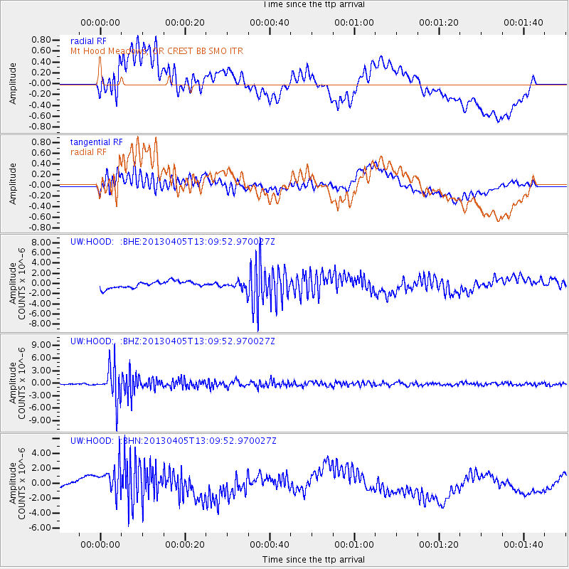
HOOD Mt Hood Meadows, OR CREST BB SMO - Earthquake Result Viewer
*The percent match for this event was below the threshold and hence no stack was calculated.
| Earthquake location: |
E. Russia-N.E. China Border Reg. |
| Earthquake latitude/longitude: |
42.7/131.0 |
| Earthquake time(UTC): |
2013/04/05 (095) 13:00:02 GMT |
| Earthquake Depth: |
563 km |
| Earthquake Magnitude: |
6.3 MW, 6.2 MB, 6.4 MW |
| Earthquake Catalog/Contributor: |
NEIC PDE/NEIC PDE-W |
|
| Network: |
UW Pacific Northwest Regional Seismic Network |
| Station: |
HOOD Mt Hood Meadows, OR CREST BB SMO |
| Lat/Lon: |
45.32 N/121.65 W |
| Elevation: |
1520 m |
|
| Distance: |
71.1 deg |
| Az: |
45.389 deg |
| Baz: |
311.976 deg |
| Ray Param: |
$rayparam |
*The percent match for this event was below the threshold and hence was not used in the summary stack. |
|
| Radial Match: |
39.377502 % |
| Radial Bump: |
400 |
| Transverse Match: |
45.45182 % |
| Transverse Bump: |
400 |
| SOD ConfigId: |
512894 |
| Insert Time: |
2013-09-13 00:30:49.101 +0000 |
| GWidth: |
2.5 |
| Max Bumps: |
400 |
| Tol: |
0.001 |
|
Signal To Noise
| Channel | StoN | STA | LTA |
| UW:HOOD: :BHZ:20130405T13:09:52.970027Z | 30.768023 | 4.1512794E-6 | 1.3492189E-7 |
| UW:HOOD: :BHN:20130405T13:09:52.970027Z | 1.4561293 | 2.2040763E-6 | 1.5136543E-6 |
| UW:HOOD: :BHE:20130405T13:09:52.970027Z | 1.3399442 | 8.5742295E-7 | 6.3989455E-7 |
| Arrivals |
| Ps | |
| PpPs | |
| PsPs/PpSs | |


