You are here: Home > Network List > TA - USArray Transportable Network (new EarthScope stations) Stations List
> Station R11A Troy Canyon, Currant, NV, USA > Earthquake Result Viewer
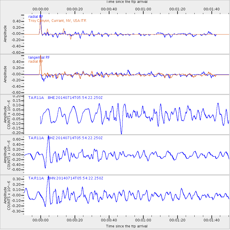
R11A Troy Canyon, Currant, NV, USA - Earthquake Result Viewer
*The percent match for this event was below the threshold and hence no stack was calculated.
| Earthquake location: |
Easter Island Region |
| Earthquake latitude/longitude: |
-26.7/-114.5 |
| Earthquake time(UTC): |
2014/07/14 (195) 05:44:16 GMT |
| Earthquake Depth: |
15 km |
| Earthquake Magnitude: |
5.5 MW, 5.4 mB, 5.3 Ms, 5.0 Ms7 |
| Earthquake Catalog/Contributor: |
ISC/ISC |
|
| Network: |
TA USArray Transportable Network (new EarthScope stations) |
| Station: |
R11A Troy Canyon, Currant, NV, USA |
| Lat/Lon: |
38.35 N/115.59 W |
| Elevation: |
1756 m |
|
| Distance: |
64.7 deg |
| Az: |
359.056 deg |
| Baz: |
178.926 deg |
| Ray Param: |
$rayparam |
*The percent match for this event was below the threshold and hence was not used in the summary stack. |
|
| Radial Match: |
73.82453 % |
| Radial Bump: |
311 |
| Transverse Match: |
69.66141 % |
| Transverse Bump: |
400 |
| SOD ConfigId: |
3390531 |
| Insert Time: |
2019-04-12 21:28:06.877 +0000 |
| GWidth: |
2.5 |
| Max Bumps: |
400 |
| Tol: |
0.001 |
|
Signal To Noise
| Channel | StoN | STA | LTA |
| TA:R11A: :BHZ:20140714T05:54:22.250Z | 6.0223 | 3.390216E-7 | 5.6294372E-8 |
| TA:R11A: :BHN:20140714T05:54:22.250Z | 3.2811556 | 1.6252348E-7 | 4.9532392E-8 |
| TA:R11A: :BHE:20140714T05:54:22.250Z | 1.1084919 | 6.4586594E-8 | 5.8265282E-8 |
| Arrivals |
| Ps | |
| PpPs | |
| PsPs/PpSs | |


