You are here: Home > Network List > TA - USArray Transportable Network (new EarthScope stations) Stations List
> Station X43A Marvell, AR, USA > Earthquake Result Viewer
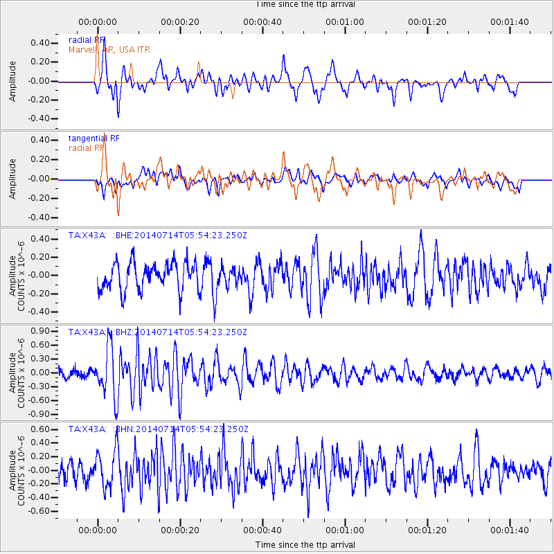
X43A Marvell, AR, USA - Earthquake Result Viewer
*The percent match for this event was below the threshold and hence no stack was calculated.
| Earthquake location: |
Easter Island Region |
| Earthquake latitude/longitude: |
-26.7/-114.5 |
| Earthquake time(UTC): |
2014/07/14 (195) 05:44:16 GMT |
| Earthquake Depth: |
15 km |
| Earthquake Magnitude: |
5.5 MW, 5.4 mB, 5.3 Ms, 5.0 Ms7 |
| Earthquake Catalog/Contributor: |
ISC/ISC |
|
| Network: |
TA USArray Transportable Network (new EarthScope stations) |
| Station: |
X43A Marvell, AR, USA |
| Lat/Lon: |
34.52 N/90.88 W |
| Elevation: |
53 m |
|
| Distance: |
64.9 deg |
| Az: |
21.433 deg |
| Baz: |
203.321 deg |
| Ray Param: |
$rayparam |
*The percent match for this event was below the threshold and hence was not used in the summary stack. |
|
| Radial Match: |
68.307976 % |
| Radial Bump: |
400 |
| Transverse Match: |
44.73527 % |
| Transverse Bump: |
400 |
| SOD ConfigId: |
3390531 |
| Insert Time: |
2019-04-12 21:28:46.876 +0000 |
| GWidth: |
2.5 |
| Max Bumps: |
400 |
| Tol: |
0.001 |
|
Signal To Noise
| Channel | StoN | STA | LTA |
| TA:X43A: :BHZ:20140714T05:54:23.250Z | 4.1764216 | 5.594858E-7 | 1.3396296E-7 |
| TA:X43A: :BHN:20140714T05:54:23.250Z | 1.4491065 | 2.8544918E-7 | 1.9698288E-7 |
| TA:X43A: :BHE:20140714T05:54:23.250Z | 0.5779842 | 8.476404E-8 | 1.466546E-7 |
| Arrivals |
| Ps | |
| PpPs | |
| PsPs/PpSs | |


