You are here: Home > Network List > II - Global Seismograph Network (GSN - IRIS/IDA) Stations List
> Station ABPO Ambohimpanompo, Madagascar > Earthquake Result Viewer
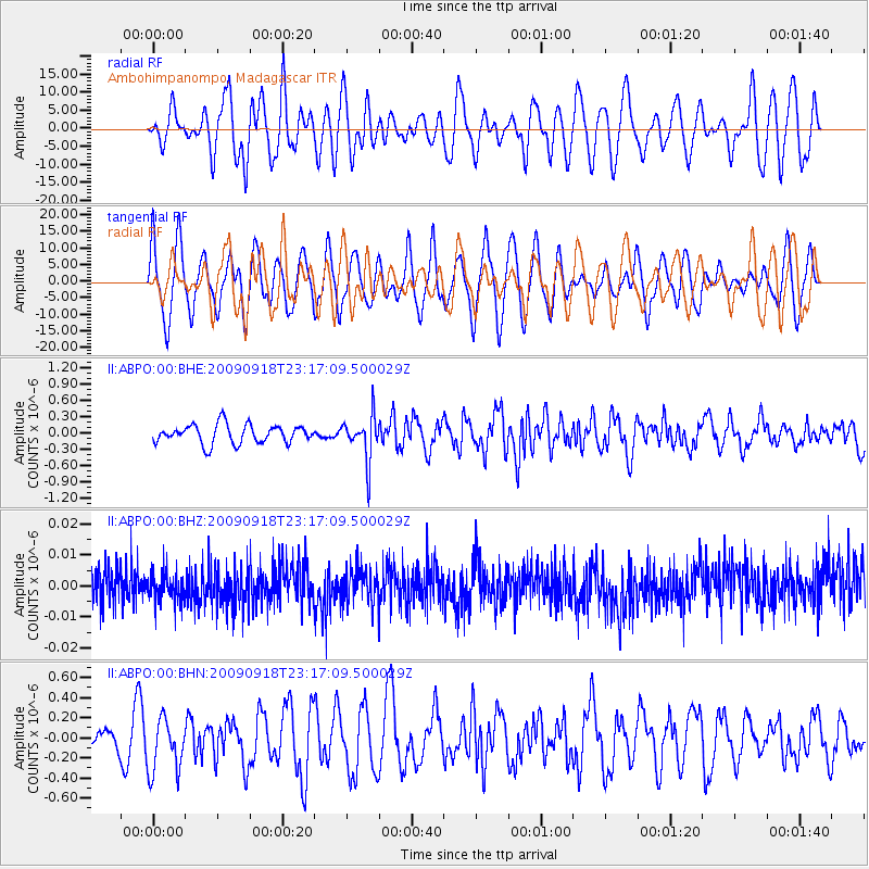
ABPO Ambohimpanompo, Madagascar - Earthquake Result Viewer
*The percent match for this event was below the threshold and hence no stack was calculated.
| Earthquake location: |
South Of Bali, Indonesia |
| Earthquake latitude/longitude: |
-9.1/115.6 |
| Earthquake time(UTC): |
2009/09/18 (261) 23:06:57 GMT |
| Earthquake Depth: |
79 km |
| Earthquake Magnitude: |
6.0 MB, 5.7 MW, 5.7 MW |
| Earthquake Catalog/Contributor: |
WHDF/NEIC |
|
| Network: |
II Global Seismograph Network (GSN - IRIS/IDA) |
| Station: |
ABPO Ambohimpanompo, Madagascar |
| Lat/Lon: |
19.02 S/47.23 E |
| Elevation: |
1528 m |
|
| Distance: |
66.7 deg |
| Az: |
253.242 deg |
| Baz: |
91.955 deg |
| Ray Param: |
$rayparam |
*The percent match for this event was below the threshold and hence was not used in the summary stack. |
|
| Radial Match: |
45.569798 % |
| Radial Bump: |
400 |
| Transverse Match: |
53.846058 % |
| Transverse Bump: |
400 |
| SOD ConfigId: |
1 |
| Insert Time: |
2010-02-19 00:16:28.198 +0000 |
| GWidth: |
2.5 |
| Max Bumps: |
400 |
| Tol: |
0.001 |
|
Signal To Noise
| Channel | StoN | STA | LTA |
| II:ABPO:00:BHZ:20090918T23:17:09.500029Z | 0.8808337 | 5.0391167E-9 | 5.720849E-9 |
| II:ABPO:00:BHN:20090918T23:17:09.500029Z | 1.481755 | 2.7020081E-7 | 1.8235187E-7 |
| II:ABPO:00:BHE:20090918T23:17:09.500029Z | 2.4006476 | 4.1558172E-7 | 1.7311234E-7 |
| Arrivals |
| Ps | |
| PpPs | |
| PsPs/PpSs | |


