You are here: Home > Network List > TA - USArray Transportable Network (new EarthScope stations) Stations List
> Station I39A Houston, MN, USA > Earthquake Result Viewer
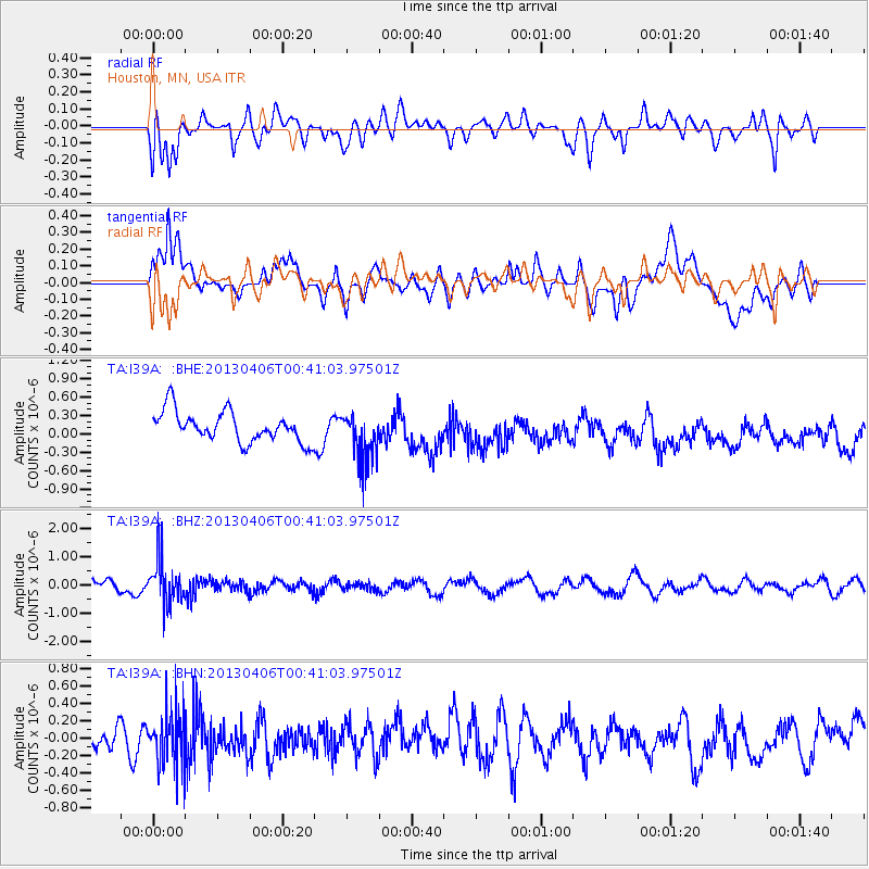
I39A Houston, MN, USA - Earthquake Result Viewer
*The percent match for this event was below the threshold and hence no stack was calculated.
| Earthquake location: |
E. Russia-N.E. China Border Reg. |
| Earthquake latitude/longitude: |
42.7/131.0 |
| Earthquake time(UTC): |
2013/04/06 (096) 00:29:55 GMT |
| Earthquake Depth: |
563 km |
| Earthquake Magnitude: |
5.8 MW, 5.5 MB, 5.9 MW |
| Earthquake Catalog/Contributor: |
NEIC PDE/NEIC PDE-W |
|
| Network: |
TA USArray Transportable Network (new EarthScope stations) |
| Station: |
I39A Houston, MN, USA |
| Lat/Lon: |
43.85 N/91.52 W |
| Elevation: |
393 m |
|
| Distance: |
85.8 deg |
| Az: |
29.345 deg |
| Baz: |
330.055 deg |
| Ray Param: |
$rayparam |
*The percent match for this event was below the threshold and hence was not used in the summary stack. |
|
| Radial Match: |
54.67478 % |
| Radial Bump: |
400 |
| Transverse Match: |
40.049797 % |
| Transverse Bump: |
400 |
| SOD ConfigId: |
512894 |
| Insert Time: |
2013-09-13 01:47:42.008 +0000 |
| GWidth: |
2.5 |
| Max Bumps: |
400 |
| Tol: |
0.001 |
|
Signal To Noise
| Channel | StoN | STA | LTA |
| TA:I39A: :BHZ:20130406T00:41:03.97501Z | 3.2212455 | 7.967036E-7 | 2.4732782E-7 |
| TA:I39A: :BHN:20130406T00:41:03.97501Z | 1.5393865 | 3.3521678E-7 | 2.1775999E-7 |
| TA:I39A: :BHE:20130406T00:41:03.97501Z | 1.7560284 | 4.3437961E-7 | 2.473648E-7 |
| Arrivals |
| Ps | |
| PpPs | |
| PsPs/PpSs | |


