You are here: Home > Network List > TA - USArray Transportable Network (new EarthScope stations) Stations List
> Station L41A Preston, IA, USA > Earthquake Result Viewer
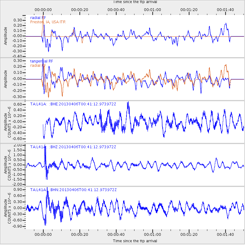
L41A Preston, IA, USA - Earthquake Result Viewer
*The percent match for this event was below the threshold and hence no stack was calculated.
| Earthquake location: |
E. Russia-N.E. China Border Reg. |
| Earthquake latitude/longitude: |
42.7/131.0 |
| Earthquake time(UTC): |
2013/04/06 (096) 00:29:55 GMT |
| Earthquake Depth: |
563 km |
| Earthquake Magnitude: |
5.8 MW, 5.5 MB, 5.9 MW |
| Earthquake Catalog/Contributor: |
NEIC PDE/NEIC PDE-W |
|
| Network: |
TA USArray Transportable Network (new EarthScope stations) |
| Station: |
L41A Preston, IA, USA |
| Lat/Lon: |
42.08 N/90.50 W |
| Elevation: |
238 m |
|
| Distance: |
87.7 deg |
| Az: |
29.569 deg |
| Baz: |
330.764 deg |
| Ray Param: |
$rayparam |
*The percent match for this event was below the threshold and hence was not used in the summary stack. |
|
| Radial Match: |
58.976383 % |
| Radial Bump: |
400 |
| Transverse Match: |
61.116726 % |
| Transverse Bump: |
400 |
| SOD ConfigId: |
512894 |
| Insert Time: |
2013-09-13 01:50:22.824 +0000 |
| GWidth: |
2.5 |
| Max Bumps: |
400 |
| Tol: |
0.001 |
|
Signal To Noise
| Channel | StoN | STA | LTA |
| TA:L41A: :BHZ:20130406T00:41:12.973972Z | 3.2791853 | 6.33391E-7 | 1.9315497E-7 |
| TA:L41A: :BHN:20130406T00:41:12.973972Z | 2.8366098 | 4.6175668E-7 | 1.627847E-7 |
| TA:L41A: :BHE:20130406T00:41:12.973972Z | 0.9051184 | 1.873141E-7 | 2.0694984E-7 |
| Arrivals |
| Ps | |
| PpPs | |
| PsPs/PpSs | |


