You are here: Home > Network List > TA - USArray Transportable Network (new EarthScope stations) Stations List
> Station O41A Passley's Farm, La Prairie, IL, USA > Earthquake Result Viewer
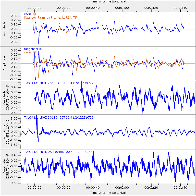
O41A Passley's Farm, La Prairie, IL, USA - Earthquake Result Viewer
*The percent match for this event was below the threshold and hence no stack was calculated.
| Earthquake location: |
E. Russia-N.E. China Border Reg. |
| Earthquake latitude/longitude: |
42.7/131.0 |
| Earthquake time(UTC): |
2013/04/06 (096) 00:29:55 GMT |
| Earthquake Depth: |
563 km |
| Earthquake Magnitude: |
5.8 MW, 5.5 MB, 5.9 MW |
| Earthquake Catalog/Contributor: |
NEIC PDE/NEIC PDE-W |
|
| Network: |
TA USArray Transportable Network (new EarthScope stations) |
| Station: |
O41A Passley's Farm, La Prairie, IL, USA |
| Lat/Lon: |
40.12 N/90.88 W |
| Elevation: |
203 m |
|
| Distance: |
89.3 deg |
| Az: |
30.782 deg |
| Baz: |
330.544 deg |
| Ray Param: |
$rayparam |
*The percent match for this event was below the threshold and hence was not used in the summary stack. |
|
| Radial Match: |
62.094116 % |
| Radial Bump: |
400 |
| Transverse Match: |
70.397736 % |
| Transverse Bump: |
400 |
| SOD ConfigId: |
512894 |
| Insert Time: |
2013-09-13 01:53:39.934 +0000 |
| GWidth: |
2.5 |
| Max Bumps: |
400 |
| Tol: |
0.001 |
|
Signal To Noise
| Channel | StoN | STA | LTA |
| TA:O41A: :BHZ:20130406T00:41:20.223972Z | 2.2418659 | 5.386576E-7 | 2.40272E-7 |
| TA:O41A: :BHN:20130406T00:41:20.223972Z | 1.1713183 | 1.587827E-7 | 1.3555896E-7 |
| TA:O41A: :BHE:20130406T00:41:20.223972Z | 1.563521 | 2.9541516E-7 | 1.8894224E-7 |
| Arrivals |
| Ps | |
| PpPs | |
| PsPs/PpSs | |


