You are here: Home > Network List > US - United States National Seismic Network Stations List
> Station AMTX Amarillo, Texas, USA > Earthquake Result Viewer
AMTX Amarillo, Texas, USA - Earthquake Result Viewer
*The percent match for this event was below the threshold and hence no stack was calculated.
| Earthquake location: |
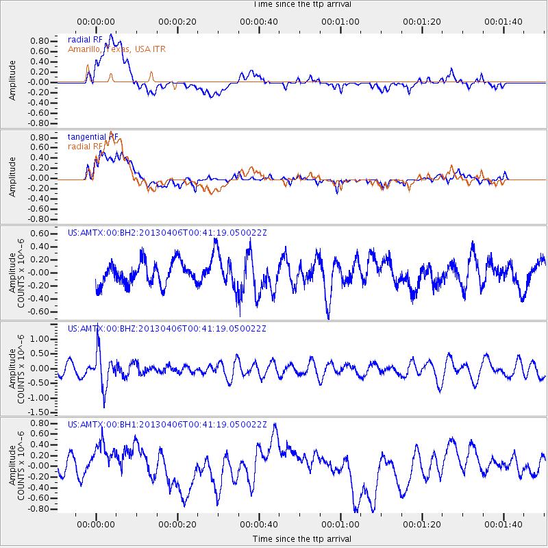
E. Russia-N.E. China Border Reg. |
| Earthquake latitude/longitude: |
42.7/131.0 |
| Earthquake time(UTC): |
2013/04/06 (096) 00:29:55 GMT |
| Earthquake Depth: |
563 km |
| Earthquake Magnitude: |
5.8 MW, 5.5 MB, 5.9 MW |
| Earthquake Catalog/Contributor: |
NEIC PDE/NEIC PDE-W |
|
| Network: |
US United States National Seismic Network |
| Station: |
AMTX Amarillo, Texas, USA |
| Lat/Lon: |
34.53 N/101.41 W |
| Elevation: |
1010 m |
|
| Distance: |
89.4 deg |
| Az: |
40.845 deg |
| Baz: |
324.287 deg |
| Ray Param: |
$rayparam |
*The percent match for this event was below the threshold and hence was not used in the summary stack. |
|
| Radial Match: |
32.569687 % |
| Radial Bump: |
400 |
| Transverse Match: |
46.563847 % |
| Transverse Bump: |
400 |
| SOD ConfigId: |
512894 |
| Insert Time: |
2013-09-13 02:00:15.705 +0000 |
| GWidth: |
2.5 |
| Max Bumps: |
400 |
| Tol: |
0.001 |
|
Signal To Noise
| Channel | StoN | STA | LTA |
| US:AMTX:00:BHZ:20130406T00:41:19.050022Z | 2.8837914 | 6.081805E-7 | 2.1089616E-7 |
| US:AMTX:00:BH1:20130406T00:41:19.050022Z | 1.0105397 | 3.9344644E-7 | 3.893429E-7 |
| US:AMTX:00:BH2:20130406T00:41:19.050022Z | 1.5804809 | 2.4674895E-7 | 1.561227E-7 |
| Arrivals |
| Ps | |
| PpPs | |
| PsPs/PpSs | |


