You are here: Home > Network List > US - United States National Seismic Network Stations List
> Station HAWA Hanford, Washington, USA > Earthquake Result Viewer
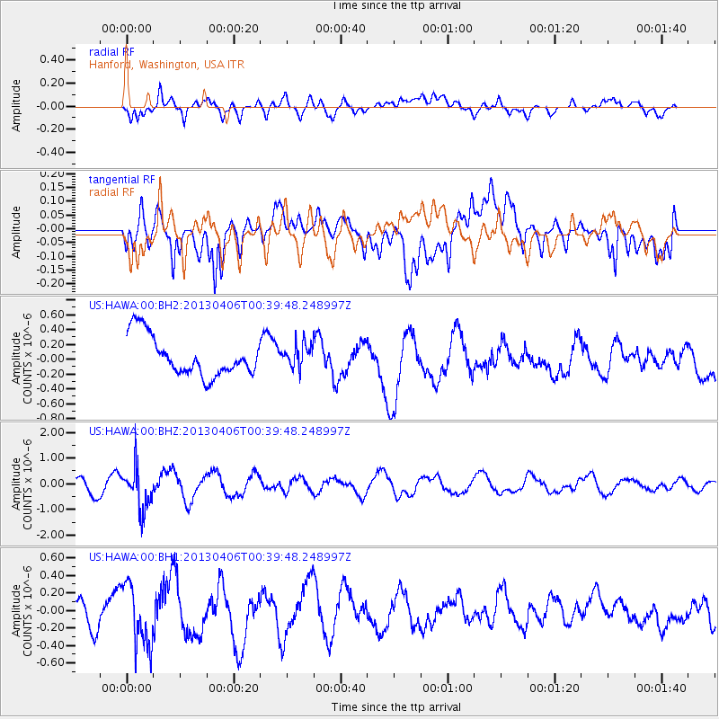
HAWA Hanford, Washington, USA - Earthquake Result Viewer
*The percent match for this event was below the threshold and hence no stack was calculated.
| Earthquake location: |
E. Russia-N.E. China Border Reg. |
| Earthquake latitude/longitude: |
42.7/131.0 |
| Earthquake time(UTC): |
2013/04/06 (096) 00:29:55 GMT |
| Earthquake Depth: |
563 km |
| Earthquake Magnitude: |
5.8 MW, 5.5 MB, 5.9 MW |
| Earthquake Catalog/Contributor: |
NEIC PDE/NEIC PDE-W |
|
| Network: |
US United States National Seismic Network |
| Station: |
HAWA Hanford, Washington, USA |
| Lat/Lon: |
46.39 N/119.53 W |
| Elevation: |
364 m |
|
| Distance: |
71.5 deg |
| Az: |
43.483 deg |
| Baz: |
312.894 deg |
| Ray Param: |
$rayparam |
*The percent match for this event was below the threshold and hence was not used in the summary stack. |
|
| Radial Match: |
64.43739 % |
| Radial Bump: |
400 |
| Transverse Match: |
47.503063 % |
| Transverse Bump: |
400 |
| SOD ConfigId: |
512894 |
| Insert Time: |
2013-09-13 02:01:05.526 +0000 |
| GWidth: |
2.5 |
| Max Bumps: |
400 |
| Tol: |
0.001 |
|
Signal To Noise
| Channel | StoN | STA | LTA |
| US:HAWA:00:BHZ:20130406T00:39:48.248997Z | 3.3710911 | 8.1696805E-7 | 2.423453E-7 |
| US:HAWA:00:BH1:20130406T00:39:48.248997Z | 1.26782 | 3.4999007E-7 | 2.760566E-7 |
| US:HAWA:00:BH2:20130406T00:39:48.248997Z | 0.57854193 | 1.5504408E-7 | 2.6799108E-7 |
| Arrivals |
| Ps | |
| PpPs | |
| PsPs/PpSs | |


