You are here: Home > Network List > UW - Pacific Northwest Regional Seismic Network Stations List
> Station LEBA Lebam, WA, USA > Earthquake Result Viewer
LEBA Lebam, WA, USA - Earthquake Result Viewer
*The percent match for this event was below the threshold and hence no stack was calculated.
| Earthquake location: |
E. Russia-N.E. China Border Reg. |
| Earthquake latitude/longitude: |
42.7/131.0 |
| Earthquake time(UTC): |
2013/04/06 (096) 00:29:55 GMT |
| Earthquake Depth: |
563 km |
| Earthquake Magnitude: |
5.8 MW, 5.5 MB, 5.9 MW |
| Earthquake Catalog/Contributor: |
NEIC PDE/NEIC PDE-W |
|
| Network: |
UW Pacific Northwest Regional Seismic Network |
| Station: |
LEBA Lebam, WA, USA |
| Lat/Lon: |
46.55 N/123.56 W |
| Elevation: |
73 m |
|
| Distance: |
69.3 deg |
| Az: |
45.33 deg |
| Baz: |
310.601 deg |
| Ray Param: |
$rayparam |
*The percent match for this event was below the threshold and hence was not used in the summary stack. |
|
| Radial Match: |
61.275646 % |
| Radial Bump: |
400 |
| Transverse Match: |
52.57648 % |
| Transverse Bump: |
400 |
| SOD ConfigId: |
512894 |
| Insert Time: |
2013-09-13 02:04:50.537 +0000 |
| GWidth: |
2.5 |
| Max Bumps: |
400 |
| Tol: |
0.001 |
|
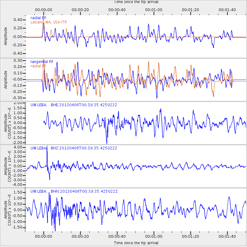
Signal To Noise
| Channel | StoN | STA | LTA |
| UW:LEBA: :BHZ:20130406T00:39:35.425022Z | 2.6614118 | 1.1444807E-6 | 4.300277E-7 |
| UW:LEBA: :BHN:20130406T00:39:35.425022Z | 1.3969043 | 6.2327535E-7 | 4.4618326E-7 |
| UW:LEBA: :BHE:20130406T00:39:35.425022Z | 1.7322788 | 6.766388E-7 | 3.9060617E-7 |
| Arrivals |
| Ps | |
| PpPs | |
| PsPs/PpSs | |


