You are here: Home > Network List > AK - Alaska Regional Network Stations List
> Station DIV Divide Microwave > Earthquake Result Viewer
DIV Divide Microwave - Earthquake Result Viewer
| Earthquake location: |
Irian Jaya, Indonesia |
| Earthquake latitude/longitude: |
-3.5/138.5 |
| Earthquake time(UTC): |
2013/04/06 (096) 04:42:35 GMT |
| Earthquake Depth: |
66 km |
| Earthquake Magnitude: |
7.0 MW, 6.6 MB, 7.0 MW |
| Earthquake Catalog/Contributor: |
NEIC PDE/NEIC PDE-W |
|
| Network: |
AK Alaska Regional Network |
| Station: |
DIV Divide Microwave |
| Lat/Lon: |
61.13 N/145.77 W |
| Elevation: |
939 m |
|
| Distance: |
86.2 deg |
| Az: |
28.126 deg |
| Baz: |
255.824 deg |
| Ray Param: |
0.044085667 |
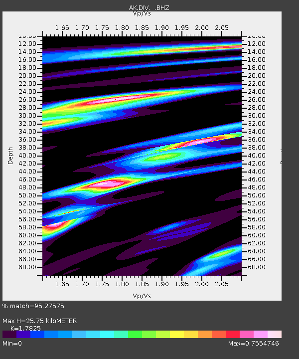
| Estimated Moho Depth: |
25.75 km |
| Estimated Crust Vp/Vs: |
1.78 |
| Assumed Crust Vp: |
6.566 km/s |
| Estimated Crust Vs: |
3.684 km/s |
| Estimated Crust Poisson's Ratio: |
0.27 |
|
| Radial Match: |
95.27575 % |
| Radial Bump: |
400 |
| Transverse Match: |
88.93048 % |
| Transverse Bump: |
400 |
| SOD ConfigId: |
512894 |
| Insert Time: |
2013-09-13 02:09:48.870 +0000 |
| GWidth: |
2.5 |
| Max Bumps: |
400 |
| Tol: |
0.001 |
|

Signal To Noise
| Channel | StoN | STA | LTA |
| AK:DIV: :BHZ:20130406T04:54:38.940017Z | 22.736471 | 3.879911E-6 | 1.7064701E-7 |
| AK:DIV: :BHN:20130406T04:54:38.940017Z | 3.9759943 | 7.404724E-7 | 1.8623577E-7 |
| AK:DIV: :BHE:20130406T04:54:38.940017Z | 9.398307 | 1.2301764E-6 | 1.3089341E-7 |
| Arrivals |
| Ps | 3.1 SECOND |
| PpPs | 11 SECOND |
| PsPs/PpSs | 14 SECOND |


