You are here: Home > Network List > AK - Alaska Regional Network Stations List
> Station DOT Dot Lake > Earthquake Result Viewer
DOT Dot Lake - Earthquake Result Viewer
| Earthquake location: |
Irian Jaya, Indonesia |
| Earthquake latitude/longitude: |
-3.5/138.5 |
| Earthquake time(UTC): |
2013/04/06 (096) 04:42:35 GMT |
| Earthquake Depth: |
66 km |
| Earthquake Magnitude: |
7.0 MW, 6.6 MB, 7.0 MW |
| Earthquake Catalog/Contributor: |
NEIC PDE/NEIC PDE-W |
|
| Network: |
AK Alaska Regional Network |
| Station: |
DOT Dot Lake |
| Lat/Lon: |
63.65 N/144.06 W |
| Elevation: |
671 m |
|
| Distance: |
87.6 deg |
| Az: |
25.85 deg |
| Baz: |
257.214 deg |
| Ray Param: |
0.04309739 |
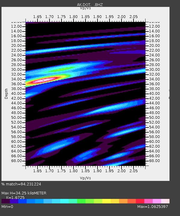
| Estimated Moho Depth: |
34.25 km |
| Estimated Crust Vp/Vs: |
1.67 |
| Assumed Crust Vp: |
6.566 km/s |
| Estimated Crust Vs: |
3.926 km/s |
| Estimated Crust Poisson's Ratio: |
0.22 |
|
| Radial Match: |
94.231224 % |
| Radial Bump: |
400 |
| Transverse Match: |
82.65751 % |
| Transverse Bump: |
400 |
| SOD ConfigId: |
512894 |
| Insert Time: |
2013-09-13 02:09:58.198 +0000 |
| GWidth: |
2.5 |
| Max Bumps: |
400 |
| Tol: |
0.001 |
|

Signal To Noise
| Channel | StoN | STA | LTA |
| AK:DOT: :BHZ:20130406T04:54:45.52803Z | 23.954428 | 3.4915338E-6 | 1.4575734E-7 |
| AK:DOT: :BHN:20130406T04:54:45.52803Z | 3.082439 | 3.0108785E-7 | 9.767845E-8 |
| AK:DOT: :BHE:20130406T04:54:45.52803Z | 8.86204 | 1.1995819E-6 | 1.3536183E-7 |
| Arrivals |
| Ps | 3.6 SECOND |
| PpPs | 14 SECOND |
| PsPs/PpSs | 17 SECOND |


