You are here: Home > Network List > AK - Alaska Regional Network Stations List
> Station RDOG Red Dog Mine, AK, USA > Earthquake Result Viewer
RDOG Red Dog Mine, AK, USA - Earthquake Result Viewer
| Earthquake location: |
Irian Jaya, Indonesia |
| Earthquake latitude/longitude: |
-3.5/138.5 |
| Earthquake time(UTC): |
2013/04/06 (096) 04:42:35 GMT |
| Earthquake Depth: |
66 km |
| Earthquake Magnitude: |
7.0 MW, 6.6 MB, 7.0 MW |
| Earthquake Catalog/Contributor: |
NEIC PDE/NEIC PDE-W |
|
| Network: |
AK Alaska Regional Network |
| Station: |
RDOG Red Dog Mine, AK, USA |
| Lat/Lon: |
68.05 N/162.90 W |
| Elevation: |
421 m |
|
| Distance: |
82.0 deg |
| Az: |
18.908 deg |
| Baz: |
239.37 deg |
| Ray Param: |
0.047051545 |
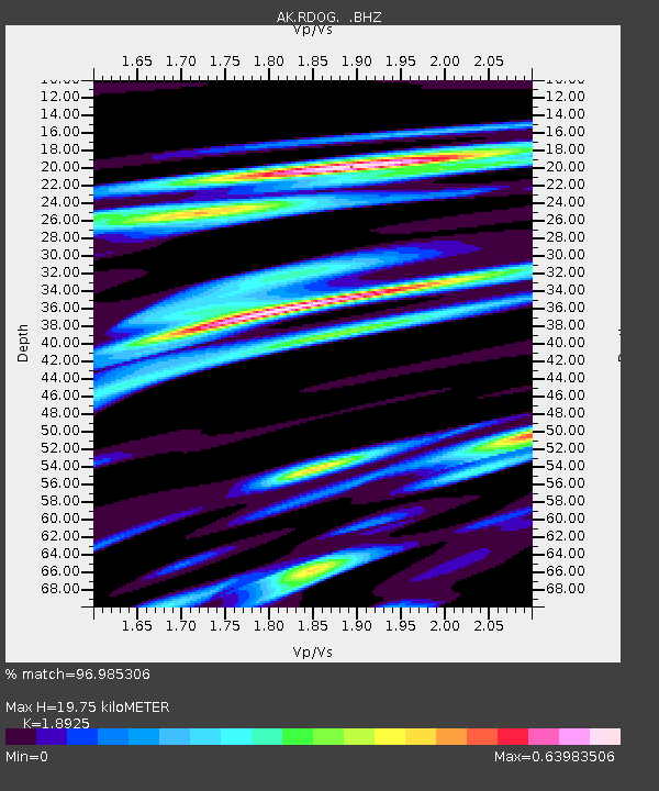
| Estimated Moho Depth: |
19.75 km |
| Estimated Crust Vp/Vs: |
1.89 |
| Assumed Crust Vp: |
5.906 km/s |
| Estimated Crust Vs: |
3.121 km/s |
| Estimated Crust Poisson's Ratio: |
0.31 |
|
| Radial Match: |
96.985306 % |
| Radial Bump: |
400 |
| Transverse Match: |
90.6519 % |
| Transverse Bump: |
400 |
| SOD ConfigId: |
512894 |
| Insert Time: |
2013-09-13 02:11:58.763 +0000 |
| GWidth: |
2.5 |
| Max Bumps: |
400 |
| Tol: |
0.001 |
|

Signal To Noise
| Channel | StoN | STA | LTA |
| AK:RDOG: :BHZ:20130406T04:54:17.688003Z | 35.001987 | 3.7220632E-6 | 1.06338625E-7 |
| AK:RDOG: :BHN:20130406T04:54:17.688003Z | 4.320549 | 6.4410585E-7 | 1.4907963E-7 |
| AK:RDOG: :BHE:20130406T04:54:17.688003Z | 18.742023 | 1.3266629E-6 | 7.078546E-8 |
| Arrivals |
| Ps | 3.0 SECOND |
| PpPs | 9.5 SECOND |
| PsPs/PpSs | 13 SECOND |


