You are here: Home > Network List > AT - Alaska Tsunami Warning Seismic System Stations List
> Station CHGN Chignik, Alaska > Earthquake Result Viewer
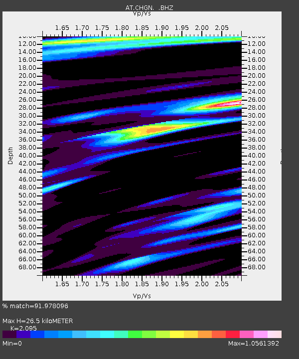
CHGN Chignik, Alaska - Earthquake Result Viewer
| Earthquake location: |
Irian Jaya, Indonesia |
| Earthquake latitude/longitude: |
-3.5/138.5 |
| Earthquake time(UTC): |
2013/04/06 (096) 04:42:35 GMT |
| Earthquake Depth: |
66 km |
| Earthquake Magnitude: |
7.0 MW, 6.6 MB, 7.0 MW |
| Earthquake Catalog/Contributor: |
NEIC PDE/NEIC PDE-W |
|
| Network: |
AT Alaska Tsunami Warning Seismic System |
| Station: |
CHGN Chignik, Alaska |
| Lat/Lon: |
56.30 N/158.41 W |
| Elevation: |
17 m |
|
| Distance: |
78.4 deg |
| Az: |
30.497 deg |
| Baz: |
245.336 deg |
| Ray Param: |
0.049532123 |
| Estimated Moho Depth: |
26.5 km |
| Estimated Crust Vp/Vs: |
2.10 |
| Assumed Crust Vp: |
6.134 km/s |
| Estimated Crust Vs: |
2.928 km/s |
| Estimated Crust Poisson's Ratio: |
0.35 |
|
| Radial Match: |
91.978096 % |
| Radial Bump: |
338 |
| Transverse Match: |
84.57046 % |
| Transverse Bump: |
400 |
| SOD ConfigId: |
512894 |
| Insert Time: |
2013-09-13 02:13:06.670 +0000 |
| GWidth: |
2.5 |
| Max Bumps: |
400 |
| Tol: |
0.001 |
|

Signal To Noise
| Channel | StoN | STA | LTA |
| AT:CHGN: :BHZ:20130406T04:53:58.33998Z | 5.427631 | 3.91674E-6 | 7.216297E-7 |
| AT:CHGN: :BHN:20130406T04:53:58.33998Z | 1.1157689 | 8.000359E-7 | 7.1702647E-7 |
| AT:CHGN: :BHE:20130406T04:53:58.33998Z | 3.4405346 | 1.5991945E-6 | 4.648099E-7 |
| Arrivals |
| Ps | 4.8 SECOND |
| PpPs | 13 SECOND |
| PsPs/PpSs | 18 SECOND |


