You are here: Home > Network List > AU - Australian Seismological Centre Stations List
> Station BLDU Ballidu, Western Australia > Earthquake Result Viewer
BLDU Ballidu, Western Australia - Earthquake Result Viewer
| Earthquake location: |
Irian Jaya, Indonesia |
| Earthquake latitude/longitude: |
-3.5/138.5 |
| Earthquake time(UTC): |
2013/04/06 (096) 04:42:35 GMT |
| Earthquake Depth: |
66 km |
| Earthquake Magnitude: |
7.0 MW, 6.6 MB, 7.0 MW |
| Earthquake Catalog/Contributor: |
NEIC PDE/NEIC PDE-W |
|
| Network: |
AU Australian Seismological Centre |
| Station: |
BLDU Ballidu, Western Australia |
| Lat/Lon: |
30.61 S/116.71 E |
| Elevation: |
280 m |
|
| Distance: |
33.9 deg |
| Az: |
214.975 deg |
| Baz: |
41.58 deg |
| Ray Param: |
0.077832416 |
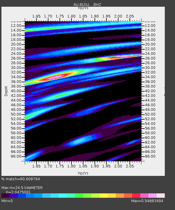
| Estimated Moho Depth: |
24.5 km |
| Estimated Crust Vp/Vs: |
2.05 |
| Assumed Crust Vp: |
6.419 km/s |
| Estimated Crust Vs: |
3.135 km/s |
| Estimated Crust Poisson's Ratio: |
0.34 |
|
| Radial Match: |
90.809784 % |
| Radial Bump: |
269 |
| Transverse Match: |
90.81312 % |
| Transverse Bump: |
272 |
| SOD ConfigId: |
512894 |
| Insert Time: |
2013-09-13 02:13:34.260 +0000 |
| GWidth: |
2.5 |
| Max Bumps: |
400 |
| Tol: |
0.001 |
|

Signal To Noise
| Channel | StoN | STA | LTA |
| AU:BLDU: :BHZ:20130406T04:48:42.143997Z | 24.228268 | 9.060691E-6 | 3.739719E-7 |
| AU:BLDU: :BHN:20130406T04:48:42.143997Z | 22.99608 | 5.514106E-6 | 2.397846E-7 |
| AU:BLDU: :BHE:20130406T04:48:42.143997Z | 1.0292284 | 1.06296145E-10 | 1.03277505E-10 |
| Arrivals |
| Ps | 4.3 SECOND |
| PpPs | 11 SECOND |
| PsPs/PpSs | 15 SECOND |


