You are here: Home > Network List > TA - USArray Transportable Network (new EarthScope stations) Stations List
> Station J04D Umpqua National Forest, Toketee, OR, USA > Earthquake Result Viewer
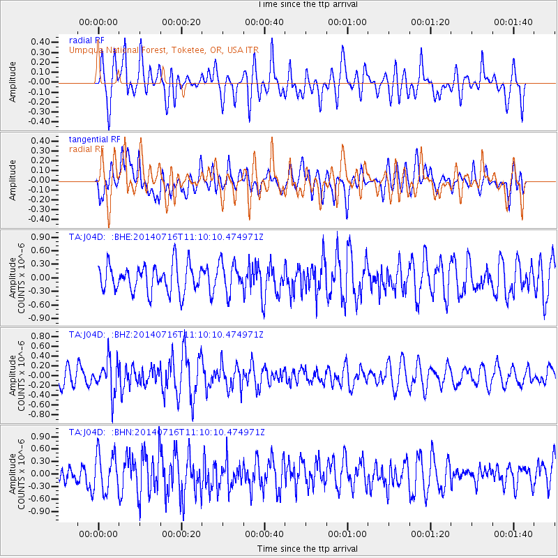
J04D Umpqua National Forest, Toketee, OR, USA - Earthquake Result Viewer
*The percent match for this event was below the threshold and hence no stack was calculated.
| Earthquake location: |
Tonga Islands |
| Earthquake latitude/longitude: |
-21.9/-175.6 |
| Earthquake time(UTC): |
2014/07/16 (197) 10:58:28 GMT |
| Earthquake Depth: |
32 km |
| Earthquake Magnitude: |
5.6 Mwc, 5.3 mb, 5.1 Ms_20, 5.4 Mwb |
| Earthquake Catalog/Contributor: |
ISC/ISC |
|
| Network: |
TA USArray Transportable Network (new EarthScope stations) |
| Station: |
J04D Umpqua National Forest, Toketee, OR, USA |
| Lat/Lon: |
43.24 N/122.11 W |
| Elevation: |
1948 m |
|
| Distance: |
81.3 deg |
| Az: |
36.429 deg |
| Baz: |
228.984 deg |
| Ray Param: |
$rayparam |
*The percent match for this event was below the threshold and hence was not used in the summary stack. |
|
| Radial Match: |
53.328197 % |
| Radial Bump: |
400 |
| Transverse Match: |
61.79824 % |
| Transverse Bump: |
400 |
| SOD ConfigId: |
3390531 |
| Insert Time: |
2019-04-12 21:34:57.032 +0000 |
| GWidth: |
2.5 |
| Max Bumps: |
400 |
| Tol: |
0.001 |
|
Signal To Noise
| Channel | StoN | STA | LTA |
| TA:J04D: :BHZ:20140716T11:10:10.474971Z | 2.7089078 | 3.5358724E-7 | 1.305276E-7 |
| TA:J04D: :BHN:20140716T11:10:10.474971Z | 1.6688279 | 4.5895965E-7 | 2.7501915E-7 |
| TA:J04D: :BHE:20140716T11:10:10.474971Z | 1.1166742 | 3.3422958E-7 | 2.9930806E-7 |
| Arrivals |
| Ps | |
| PpPs | |
| PsPs/PpSs | |


