You are here: Home > Network List > AU - Australian Seismological Centre Stations List
> Station XMIS Christmas Island Grants Well > Earthquake Result Viewer
XMIS Christmas Island Grants Well - Earthquake Result Viewer
| Earthquake location: |
Irian Jaya, Indonesia |
| Earthquake latitude/longitude: |
-3.5/138.5 |
| Earthquake time(UTC): |
2013/04/06 (096) 04:42:35 GMT |
| Earthquake Depth: |
66 km |
| Earthquake Magnitude: |
7.0 MW, 6.6 MB, 7.0 MW |
| Earthquake Catalog/Contributor: |
NEIC PDE/NEIC PDE-W |
|
| Network: |
AU Australian Seismological Centre |
| Station: |
XMIS Christmas Island Grants Well |
| Lat/Lon: |
10.48 S/105.65 E |
| Elevation: |
210 m |
|
| Distance: |
33.3 deg |
| Az: |
256.294 deg |
| Baz: |
80.385 deg |
| Ray Param: |
0.07811533 |
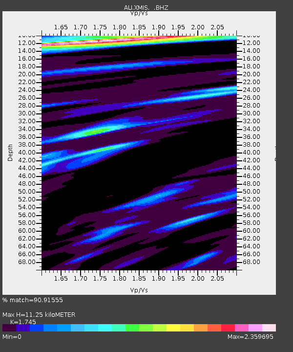
| Estimated Moho Depth: |
11.25 km |
| Estimated Crust Vp/Vs: |
1.75 |
| Assumed Crust Vp: |
4.157 km/s |
| Estimated Crust Vs: |
2.382 km/s |
| Estimated Crust Poisson's Ratio: |
0.26 |
|
| Radial Match: |
90.91555 % |
| Radial Bump: |
316 |
| Transverse Match: |
57.244827 % |
| Transverse Bump: |
400 |
| SOD ConfigId: |
512894 |
| Insert Time: |
2013-09-13 02:14:13.782 +0000 |
| GWidth: |
2.5 |
| Max Bumps: |
400 |
| Tol: |
0.001 |
|

Signal To Noise
| Channel | StoN | STA | LTA |
| AU:XMIS: :BHZ:20130406T04:48:36.79399Z | 4.3855157 | 2.8003396E-6 | 6.385429E-7 |
| AU:XMIS: :BHN:20130406T04:48:36.79399Z | 2.1621187 | 1.6378771E-6 | 7.5753337E-7 |
| AU:XMIS: :BHE:20130406T04:48:36.79399Z | 1.6933556 | 1.9144993E-6 | 1.130595E-6 |
| Arrivals |
| Ps | 2.1 SECOND |
| PpPs | 7.2 SECOND |
| PsPs/PpSs | 9.3 SECOND |


