You are here: Home > Network List > AV - Alaska Volcano Observatory Stations List
> Station AUL Lava Flow, Augustine Volcano, Alaska > Earthquake Result Viewer
AUL Lava Flow, Augustine Volcano, Alaska - Earthquake Result Viewer
| Earthquake location: |
Irian Jaya, Indonesia |
| Earthquake latitude/longitude: |
-3.5/138.5 |
| Earthquake time(UTC): |
2013/04/06 (096) 04:42:35 GMT |
| Earthquake Depth: |
66 km |
| Earthquake Magnitude: |
7.0 MW, 6.6 MB, 7.0 MW |
| Earthquake Catalog/Contributor: |
NEIC PDE/NEIC PDE-W |
|
| Network: |
AV Alaska Volcano Observatory |
| Station: |
AUL Lava Flow, Augustine Volcano, Alaska |
| Lat/Lon: |
59.38 N/153.44 W |
| Elevation: |
360 m |
|
| Distance: |
82.0 deg |
| Az: |
28.651 deg |
| Baz: |
249.23 deg |
| Ray Param: |
0.04702856 |
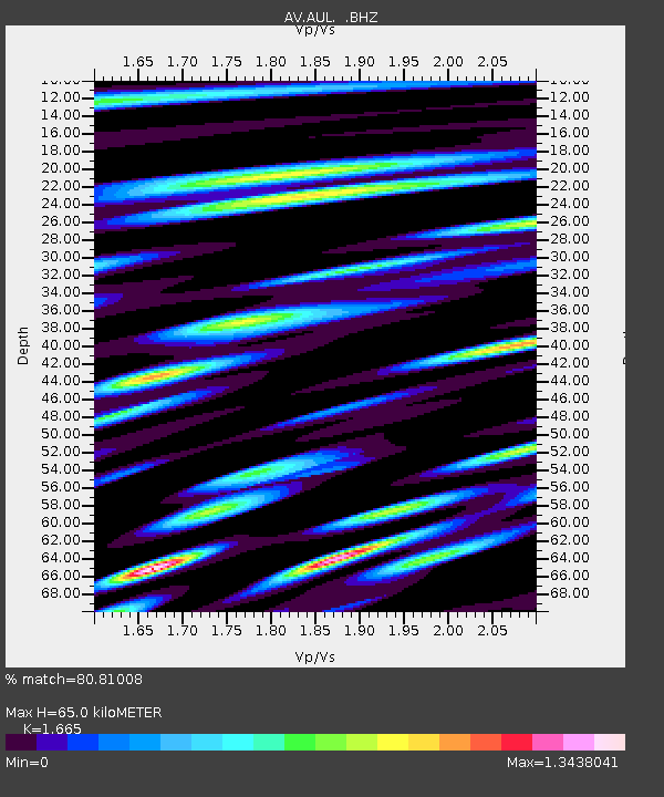
| Estimated Moho Depth: |
65.0 km |
| Estimated Crust Vp/Vs: |
1.66 |
| Assumed Crust Vp: |
5.989 km/s |
| Estimated Crust Vs: |
3.597 km/s |
| Estimated Crust Poisson's Ratio: |
0.22 |
|
| Radial Match: |
80.81008 % |
| Radial Bump: |
400 |
| Transverse Match: |
78.28514 % |
| Transverse Bump: |
400 |
| SOD ConfigId: |
512894 |
| Insert Time: |
2013-09-13 02:14:23.571 +0000 |
| GWidth: |
2.5 |
| Max Bumps: |
400 |
| Tol: |
0.001 |
|

Signal To Noise
| Channel | StoN | STA | LTA |
| AV:AUL: :BHZ:20130406T04:54:17.88002Z | 9.900464 | 3.5288454E-6 | 3.5643234E-7 |
| AV:AUL: :BHN:20130406T04:54:17.88002Z | 2.2319114 | 9.561313E-7 | 4.2839127E-7 |
| AV:AUL: :BHE:20130406T04:54:17.88002Z | 1.6884254 | 1.1439124E-6 | 6.775025E-7 |
| Arrivals |
| Ps | 7.4 SECOND |
| PpPs | 28 SECOND |
| PsPs/PpSs | 36 SECOND |


