You are here: Home > Network List > CB - China National Seismic Network Stations List
> Station HEH Heihe,Heilongjiang Province > Earthquake Result Viewer
HEH Heihe,Heilongjiang Province - Earthquake Result Viewer
| Earthquake location: |
Irian Jaya, Indonesia |
| Earthquake latitude/longitude: |
-3.5/138.5 |
| Earthquake time(UTC): |
2013/04/06 (096) 04:42:35 GMT |
| Earthquake Depth: |
66 km |
| Earthquake Magnitude: |
7.0 MW, 6.6 MB, 7.0 MW |
| Earthquake Catalog/Contributor: |
NEIC PDE/NEIC PDE-W |
|
| Network: |
CB China National Seismic Network |
| Station: |
HEH Heihe,Heilongjiang Province |
| Lat/Lon: |
50.25 N/127.41 E |
| Elevation: |
165 m |
|
| Distance: |
54.4 deg |
| Az: |
351.284 deg |
| Baz: |
166.372 deg |
| Ray Param: |
0.06529856 |
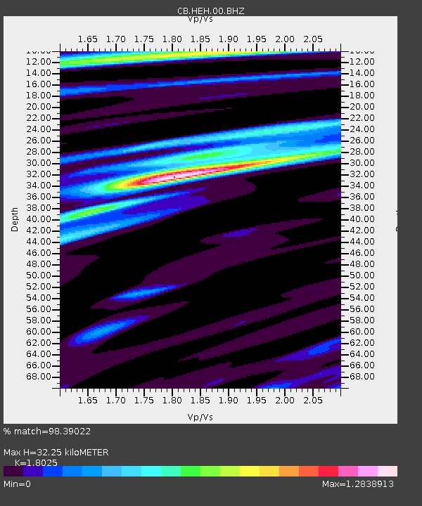
| Estimated Moho Depth: |
32.25 km |
| Estimated Crust Vp/Vs: |
1.80 |
| Assumed Crust Vp: |
6.419 km/s |
| Estimated Crust Vs: |
3.561 km/s |
| Estimated Crust Poisson's Ratio: |
0.28 |
|
| Radial Match: |
98.39022 % |
| Radial Bump: |
272 |
| Transverse Match: |
84.340576 % |
| Transverse Bump: |
400 |
| SOD ConfigId: |
512894 |
| Insert Time: |
2013-09-13 02:15:05.438 +0000 |
| GWidth: |
2.5 |
| Max Bumps: |
400 |
| Tol: |
0.001 |
|

Signal To Noise
| Channel | StoN | STA | LTA |
| CB:HEH:00:BHZ:20130406T04:51:25.510024Z | 18.81014 | 3.9185215E-6 | 2.0831963E-7 |
| CB:HEH:00:BHN:20130406T04:51:25.510024Z | 10.680674 | 1.9403856E-6 | 1.8167259E-7 |
| CB:HEH:00:BHE:20130406T04:51:25.510024Z | 2.83461 | 6.4560305E-7 | 2.2775728E-7 |
| Arrivals |
| Ps | 4.2 SECOND |
| PpPs | 13 SECOND |
| PsPs/PpSs | 18 SECOND |


