You are here: Home > Network List > CB - China National Seismic Network Stations List
> Station LZH Lanzhou,Gansu Province > Earthquake Result Viewer
LZH Lanzhou,Gansu Province - Earthquake Result Viewer
| Earthquake location: |
Irian Jaya, Indonesia |
| Earthquake latitude/longitude: |
-3.5/138.5 |
| Earthquake time(UTC): |
2013/04/06 (096) 04:42:35 GMT |
| Earthquake Depth: |
66 km |
| Earthquake Magnitude: |
7.0 MW, 6.6 MB, 7.0 MW |
| Earthquake Catalog/Contributor: |
NEIC PDE/NEIC PDE-W |
|
| Network: |
CB China National Seismic Network |
| Station: |
LZH Lanzhou,Gansu Province |
| Lat/Lon: |
36.09 N/103.84 E |
| Elevation: |
1560 m |
|
| Distance: |
51.0 deg |
| Az: |
323.669 deg |
| Baz: |
133.109 deg |
| Ray Param: |
0.06751663 |
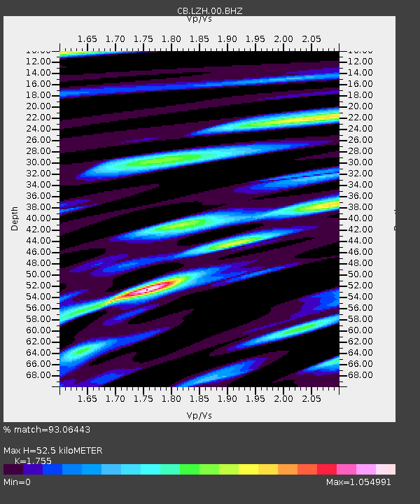
| Estimated Moho Depth: |
52.5 km |
| Estimated Crust Vp/Vs: |
1.75 |
| Assumed Crust Vp: |
6.306 km/s |
| Estimated Crust Vs: |
3.593 km/s |
| Estimated Crust Poisson's Ratio: |
0.26 |
|
| Radial Match: |
93.06443 % |
| Radial Bump: |
400 |
| Transverse Match: |
81.15597 % |
| Transverse Bump: |
400 |
| SOD ConfigId: |
512894 |
| Insert Time: |
2013-09-13 02:15:11.529 +0000 |
| GWidth: |
2.5 |
| Max Bumps: |
400 |
| Tol: |
0.001 |
|

Signal To Noise
| Channel | StoN | STA | LTA |
| CB:LZH:00:BHZ:20130406T04:51:00.360Z | 13.022705 | 1.7158565E-6 | 1.3175884E-7 |
| CB:LZH:00:BHN:20130406T04:51:00.360Z | 3.2541974 | 6.256913E-7 | 1.922721E-7 |
| CB:LZH:00:BHE:20130406T04:51:00.360Z | 4.289407 | 5.538823E-7 | 1.2912794E-7 |
| Arrivals |
| Ps | 6.6 SECOND |
| PpPs | 22 SECOND |
| PsPs/PpSs | 28 SECOND |


