You are here: Home > Network List > G - GEOSCOPE Stations List
> Station DZM Dzumac, New Caledonia > Earthquake Result Viewer
DZM Dzumac, New Caledonia - Earthquake Result Viewer
| Earthquake location: |
Irian Jaya, Indonesia |
| Earthquake latitude/longitude: |
-3.5/138.5 |
| Earthquake time(UTC): |
2013/04/06 (096) 04:42:35 GMT |
| Earthquake Depth: |
66 km |
| Earthquake Magnitude: |
7.0 MW, 6.6 MB, 7.0 MW |
| Earthquake Catalog/Contributor: |
NEIC PDE/NEIC PDE-W |
|
| Network: |
G GEOSCOPE |
| Station: |
DZM Dzumac, New Caledonia |
| Lat/Lon: |
22.07 S/166.44 E |
| Elevation: |
878 m |
|
| Distance: |
32.8 deg |
| Az: |
126.593 deg |
| Baz: |
300.236 deg |
| Ray Param: |
0.0783334 |
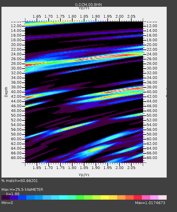
| Estimated Moho Depth: |
25.5 km |
| Estimated Crust Vp/Vs: |
1.88 |
| Assumed Crust Vp: |
5.14 km/s |
| Estimated Crust Vs: |
2.734 km/s |
| Estimated Crust Poisson's Ratio: |
0.30 |
|
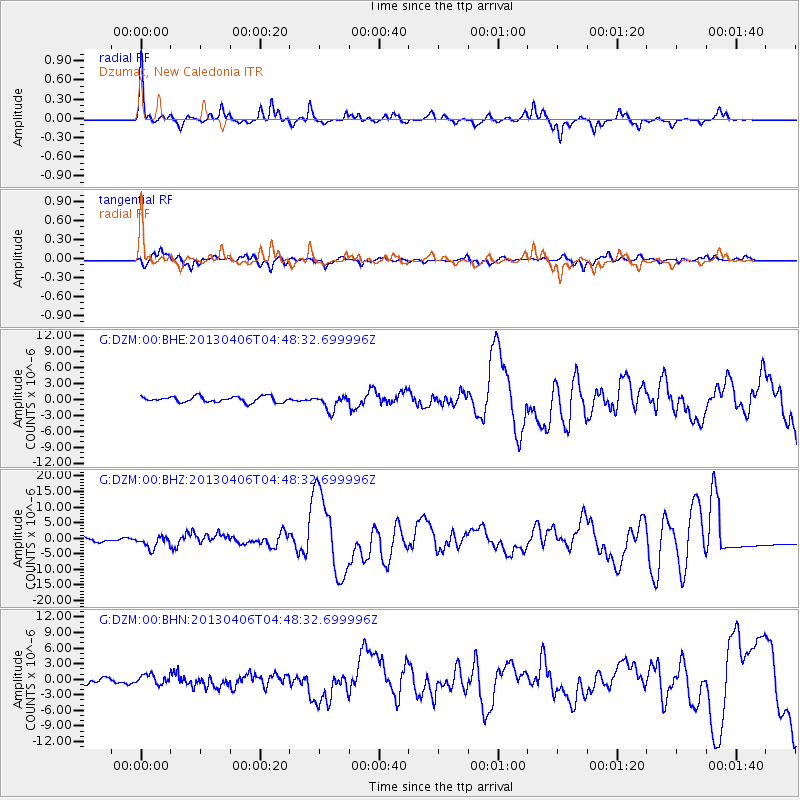
| Radial Match: |
80.66201 % |
| Radial Bump: |
310 |
| Transverse Match: |
77.935974 % |
| Transverse Bump: |
400 |
| SOD ConfigId: |
512894 |
| Insert Time: |
2013-09-13 02:16:18.318 +0000 |
| GWidth: |
2.5 |
| Max Bumps: |
400 |
| Tol: |
0.001 |
|
Signal To Noise
| Channel | StoN | STA | LTA |
| G:DZM:00:BHZ:20130406T04:48:32.699996Z | 1.8870431 | 1.9767676E-6 | 1.0475476E-6 |
| G:DZM:00:BHN:20130406T04:48:32.699996Z | 1.8385619 | 9.69664E-7 | 5.2740353E-7 |
| G:DZM:00:BHE:20130406T04:48:32.699996Z | 2.6225083 | 1.4297282E-6 | 5.4517585E-7 |
| Arrivals |
| Ps | 4.6 SECOND |
| PpPs | 14 SECOND |
| PsPs/PpSs | 18 SECOND |


