You are here: Home > Network List > G - GEOSCOPE Stations List
> Station NOUC Port Laguerre, New Caledonia > Earthquake Result Viewer
NOUC Port Laguerre, New Caledonia - Earthquake Result Viewer
| Earthquake location: |
Irian Jaya, Indonesia |
| Earthquake latitude/longitude: |
-3.5/138.5 |
| Earthquake time(UTC): |
2013/04/06 (096) 04:42:35 GMT |
| Earthquake Depth: |
66 km |
| Earthquake Magnitude: |
7.0 MW, 6.6 MB, 7.0 MW |
| Earthquake Catalog/Contributor: |
NEIC PDE/NEIC PDE-W |
|
| Network: |
G GEOSCOPE |
| Station: |
NOUC Port Laguerre, New Caledonia |
| Lat/Lon: |
22.10 S/166.30 E |
| Elevation: |
112 m |
|
| Distance: |
32.7 deg |
| Az: |
126.761 deg |
| Baz: |
300.43 deg |
| Ray Param: |
0.078379035 |
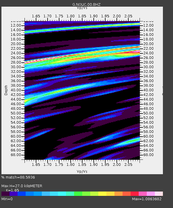
| Estimated Moho Depth: |
27.0 km |
| Estimated Crust Vp/Vs: |
1.65 |
| Assumed Crust Vp: |
5.14 km/s |
| Estimated Crust Vs: |
3.115 km/s |
| Estimated Crust Poisson's Ratio: |
0.21 |
|
| Radial Match: |
88.5936 % |
| Radial Bump: |
315 |
| Transverse Match: |
86.30361 % |
| Transverse Bump: |
384 |
| SOD ConfigId: |
512894 |
| Insert Time: |
2013-09-13 02:16:22.595 +0000 |
| GWidth: |
2.5 |
| Max Bumps: |
400 |
| Tol: |
0.001 |
|

Signal To Noise
| Channel | StoN | STA | LTA |
| G:NOUC:00:BHZ:20130406T04:48:31.849014Z | 4.168973 | 1.7523911E-6 | 4.203412E-7 |
| G:NOUC:00:BHN:20130406T04:48:31.849014Z | 1.784145 | 8.548694E-7 | 4.7914796E-7 |
| G:NOUC:00:BHE:20130406T04:48:31.849014Z | 3.0620675 | 1.6834681E-6 | 5.497815E-7 |
| Arrivals |
| Ps | 3.6 SECOND |
| PpPs | 13 SECOND |
| PsPs/PpSs | 17 SECOND |


