You are here: Home > Network List > US - United States National Seismic Network Stations List
> Station DGMT Dagmar, Montana, USA > Earthquake Result Viewer
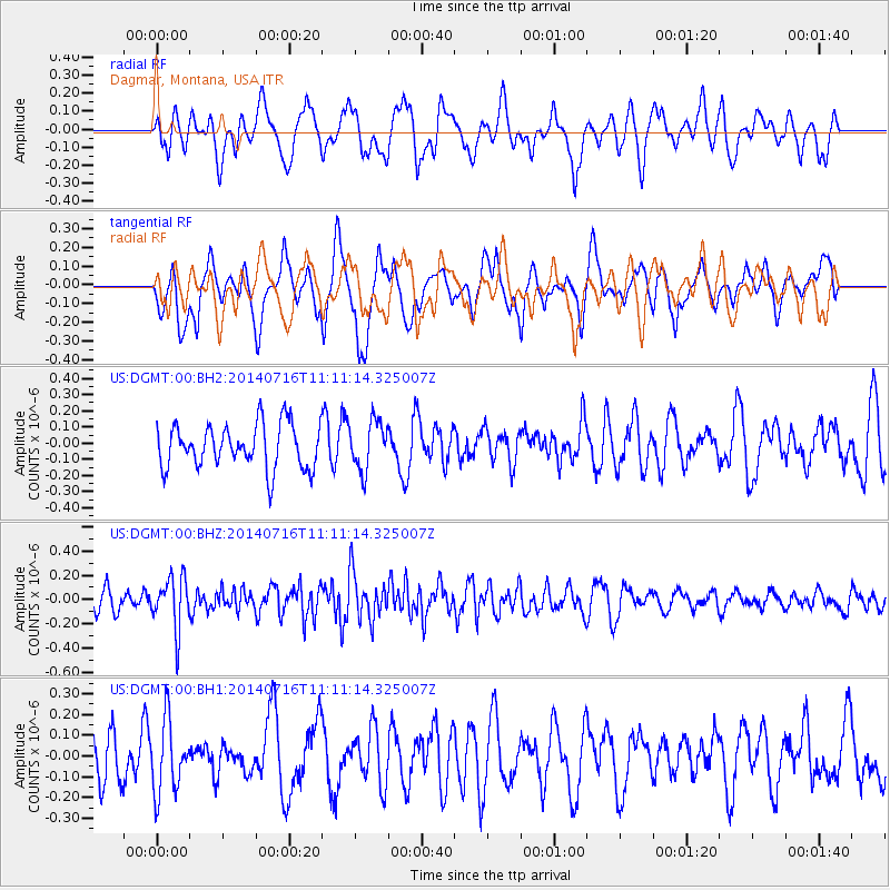
DGMT Dagmar, Montana, USA - Earthquake Result Viewer
*The percent match for this event was below the threshold and hence no stack was calculated.
| Earthquake location: |
Tonga Islands |
| Earthquake latitude/longitude: |
-21.9/-175.6 |
| Earthquake time(UTC): |
2014/07/16 (197) 10:58:28 GMT |
| Earthquake Depth: |
32 km |
| Earthquake Magnitude: |
5.6 Mwc, 5.3 mb, 5.1 Ms_20, 5.4 Mwb |
| Earthquake Catalog/Contributor: |
ISC/ISC |
|
| Network: |
US United States National Seismic Network |
| Station: |
DGMT Dagmar, Montana, USA |
| Lat/Lon: |
48.47 N/104.20 W |
| Elevation: |
0.0 m |
|
| Distance: |
94.6 deg |
| Az: |
39.243 deg |
| Baz: |
241.963 deg |
| Ray Param: |
$rayparam |
*The percent match for this event was below the threshold and hence was not used in the summary stack. |
|
| Radial Match: |
50.666218 % |
| Radial Bump: |
400 |
| Transverse Match: |
53.26942 % |
| Transverse Bump: |
397 |
| SOD ConfigId: |
3390531 |
| Insert Time: |
2019-04-12 21:35:37.197 +0000 |
| GWidth: |
2.5 |
| Max Bumps: |
400 |
| Tol: |
0.001 |
|
Signal To Noise
| Channel | StoN | STA | LTA |
| US:DGMT:00:BHZ:20140716T11:11:14.325007Z | 2.307037 | 2.1341368E-7 | 9.250552E-8 |
| US:DGMT:00:BH1:20140716T11:11:14.325007Z | 1.3576375 | 1.7220137E-7 | 1.2683898E-7 |
| US:DGMT:00:BH2:20140716T11:11:14.325007Z | 1.1087836 | 1.5099123E-7 | 1.3617736E-7 |
| Arrivals |
| Ps | |
| PpPs | |
| PsPs/PpSs | |


