You are here: Home > Network List > GO - National Seismic Network of Georgia Stations List
> Station DDFL Dedoflistskaro, Georgia > Earthquake Result Viewer
DDFL Dedoflistskaro, Georgia - Earthquake Result Viewer
| Earthquake location: |
Irian Jaya, Indonesia |
| Earthquake latitude/longitude: |
-3.5/138.5 |
| Earthquake time(UTC): |
2013/04/06 (096) 04:42:35 GMT |
| Earthquake Depth: |
66 km |
| Earthquake Magnitude: |
7.0 MW, 6.6 MB, 7.0 MW |
| Earthquake Catalog/Contributor: |
NEIC PDE/NEIC PDE-W |
|
| Network: |
GO National Seismic Network of Georgia |
| Station: |
DDFL Dedoflistskaro, Georgia |
| Lat/Lon: |
41.45 N/46.12 E |
| Elevation: |
856 m |
|
| Distance: |
94.1 deg |
| Az: |
311.145 deg |
| Baz: |
91.076 deg |
| Ray Param: |
0.04109137 |
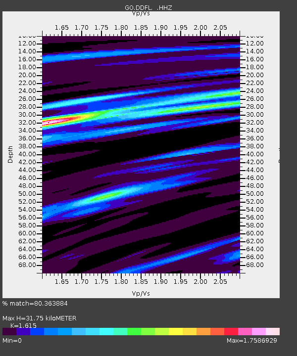
| Estimated Moho Depth: |
31.75 km |
| Estimated Crust Vp/Vs: |
1.62 |
| Assumed Crust Vp: |
6.129 km/s |
| Estimated Crust Vs: |
3.795 km/s |
| Estimated Crust Poisson's Ratio: |
0.19 |
|
| Radial Match: |
80.363884 % |
| Radial Bump: |
400 |
| Transverse Match: |
72.89967 % |
| Transverse Bump: |
400 |
| SOD ConfigId: |
512894 |
| Insert Time: |
2013-09-13 02:16:51.579 +0000 |
| GWidth: |
2.5 |
| Max Bumps: |
400 |
| Tol: |
0.001 |
|

Signal To Noise
| Channel | StoN | STA | LTA |
| GO:DDFL: :HHZ:20130406T04:55:15.62001Z | 5.671995 | 1.2390464E-6 | 2.1844983E-7 |
| GO:DDFL: :HHN:20130406T04:55:15.62001Z | 1.7537318 | 2.816506E-7 | 1.6060073E-7 |
| GO:DDFL: :HHE:20130406T04:55:15.62001Z | 1.8271668 | 2.751064E-7 | 1.5056447E-7 |
| Arrivals |
| Ps | 3.3 SECOND |
| PpPs | 13 SECOND |
| PsPs/PpSs | 17 SECOND |


