You are here: Home > Network List > IU - Global Seismograph Network (GSN - IRIS/USGS) Stations List
> Station FUNA Funafuti, Tuvalu > Earthquake Result Viewer
FUNA Funafuti, Tuvalu - Earthquake Result Viewer

| Earthquake location: |
Irian Jaya, Indonesia |
| Earthquake latitude/longitude: |
-3.5/138.5 |
| Earthquake time(UTC): |
2013/04/06 (096) 04:42:35 GMT |
| Earthquake Depth: |
66 km |
| Earthquake Magnitude: |
7.0 MW, 6.6 MB, 7.0 MW |
| Earthquake Catalog/Contributor: |
NEIC PDE/NEIC PDE-W |
|
| Network: |
IU Global Seismograph Network (GSN - IRIS/USGS) |
| Station: |
FUNA Funafuti, Tuvalu |
| Lat/Lon: |
8.53 S/179.20 E |
| Elevation: |
20 m |
|
| Distance: |
40.8 deg |
| Az: |
98.925 deg |
| Baz: |
274.491 deg |
| Ray Param: |
0.073998116 |
| Estimated Moho Depth: |
16.0 km |
| Estimated Crust Vp/Vs: |
1.60 |
| Assumed Crust Vp: |
4.24 km/s |
| Estimated Crust Vs: |
2.65 km/s |
| Estimated Crust Poisson's Ratio: |
0.18 |
|
| Radial Match: |
88.70709 % |
| Radial Bump: |
400 |
| Transverse Match: |
87.025925 % |
| Transverse Bump: |
400 |
| SOD ConfigId: |
512894 |
| Insert Time: |
2013-09-13 02:19:28.274 +0000 |
| GWidth: |
2.5 |
| Max Bumps: |
400 |
| Tol: |
0.001 |
|
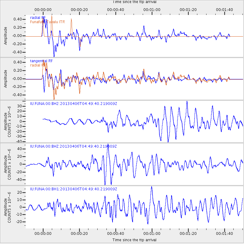
Signal To Noise
| Channel | StoN | STA | LTA |
| IU:FUNA:00:BHZ:20130406T04:49:40.219009Z | 2.5685308 | 7.191565E-6 | 2.7998751E-6 |
| IU:FUNA:00:BH1:20130406T04:49:40.219009Z | 1.561977 | 3.0819717E-6 | 1.9731224E-6 |
| IU:FUNA:00:BH2:20130406T04:49:40.219009Z | 0.77938735 | 2.8400343E-6 | 3.6439317E-6 |
| Arrivals |
| Ps | 2.3 SECOND |
| PpPs | 9.5 SECOND |
| PsPs/PpSs | 12 SECOND |


