You are here: Home > Network List > CI - Caltech Regional Seismic Network Stations List
> Station SLA SLA, Trona, CA, USA > Earthquake Result Viewer
SLA SLA, Trona, CA, USA - Earthquake Result Viewer
| Earthquake location: |
Northeastern China |
| Earthquake latitude/longitude: |
44.8/129.9 |
| Earthquake time(UTC): |
2002/09/15 (258) 08:39:32 GMT |
| Earthquake Depth: |
586 km |
| Earthquake Magnitude: |
5.8 MB, 6.4 MW, 6.4 MW |
| Earthquake Catalog/Contributor: |
WHDF/NEIC |
|
| Network: |
CI Caltech Regional Seismic Network |
| Station: |
SLA SLA, Trona, CA, USA |
| Lat/Lon: |
35.89 N/117.28 W |
| Elevation: |
1174 m |
|
| Distance: |
79.3 deg |
| Az: |
49.634 deg |
| Baz: |
318.114 deg |
| Ray Param: |
0.047262046 |
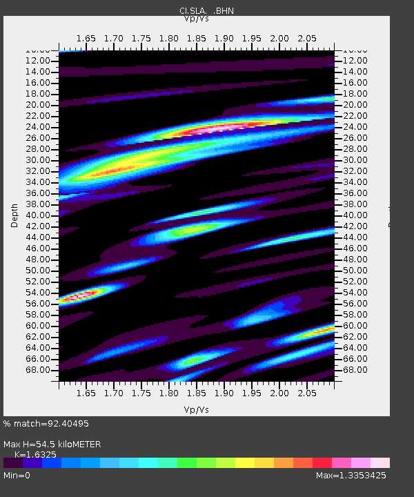
| Estimated Moho Depth: |
54.5 km |
| Estimated Crust Vp/Vs: |
1.63 |
| Assumed Crust Vp: |
6.276 km/s |
| Estimated Crust Vs: |
3.844 km/s |
| Estimated Crust Poisson's Ratio: |
0.20 |
|
| Radial Match: |
92.40495 % |
| Radial Bump: |
400 |
| Transverse Match: |
86.373184 % |
| Transverse Bump: |
400 |
| SOD ConfigId: |
3787 |
| Insert Time: |
2010-02-25 20:29:45.186 +0000 |
| GWidth: |
2.5 |
| Max Bumps: |
400 |
| Tol: |
0.001 |
|
Signal To Noise
| Channel | StoN | STA | LTA |
| CI:SLA: :BHN:20020915T08:50:06.968005Z | 5.42019 | 6.8681237E-7 | 1.2671372E-7 |
| CI:SLA: :BHE:20020915T08:50:06.968005Z | 2.9190671 | 4.777863E-7 | 1.6367773E-7 |
| CI:SLA: :BHZ:20020915T08:50:06.968005Z | 28.908556 | 2.1582412E-6 | 7.465752E-8 |
| Arrivals |
| Ps | 5.6 SECOND |
| PpPs | 22 SECOND |
| PsPs/PpSs | 28 SECOND |


