You are here: Home > Network List > GT - Global Telemetered Seismograph Network (USAF/USGS) Stations List
> Station VNDA Wright Valley (Bull Pass) Antarctica > Earthquake Result Viewer
VNDA Wright Valley (Bull Pass) Antarctica - Earthquake Result Viewer
| Earthquake location: |
Banda Sea |
| Earthquake latitude/longitude: |
-5.5/128.1 |
| Earthquake time(UTC): |
2006/01/27 (027) 16:58:53 GMT |
| Earthquake Depth: |
397 km |
| Earthquake Magnitude: |
7.0 MB, 7.6 MW, 7.5 MW |
| Earthquake Catalog/Contributor: |
WHDF/NEIC |
|
| Network: |
GT Global Telemetered Seismograph Network (USAF/USGS) |
| Station: |
VNDA Wright Valley (Bull Pass) Antarctica |
| Lat/Lon: |
77.52 S/161.85 E |
| Elevation: |
151 m |
|
| Distance: |
74.2 deg |
| Az: |
172.789 deg |
| Baz: |
324.941 deg |
| Ray Param: |
0.05132905 |
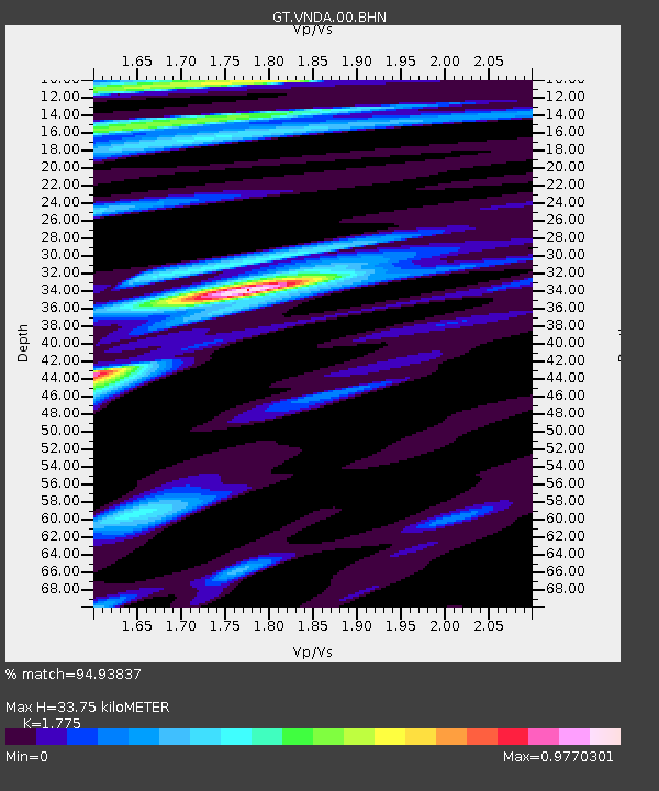
| Estimated Moho Depth: |
33.75 km |
| Estimated Crust Vp/Vs: |
1.77 |
| Assumed Crust Vp: |
6.245 km/s |
| Estimated Crust Vs: |
3.518 km/s |
| Estimated Crust Poisson's Ratio: |
0.27 |
|
| Radial Match: |
94.93837 % |
| Radial Bump: |
400 |
| Transverse Match: |
78.70684 % |
| Transverse Bump: |
400 |
| SOD ConfigId: |
4977 |
| Insert Time: |
2010-02-27 02:27:01.168 +0000 |
| GWidth: |
2.5 |
| Max Bumps: |
400 |
| Tol: |
0.001 |
|

Signal To Noise
| Channel | StoN | STA | LTA |
| GT:VNDA:00:BHN:20060127T17:09:17.125017Z | 10.098247 | 1.1854858E-6 | 1.1739522E-7 |
| GT:VNDA:00:BHE:20060127T17:09:17.125017Z | 6.5904403 | 8.5738617E-7 | 1.3009543E-7 |
| GT:VNDA:00:BHZ:20060127T17:09:17.125017Z | 14.401137 | 3.4786933E-6 | 2.4155685E-7 |
| Arrivals |
| Ps | 4.3 SECOND |
| PpPs | 15 SECOND |
| PsPs/PpSs | 19 SECOND |


