You are here: Home > Network List > IU - Global Seismograph Network (GSN - IRIS/USGS) Stations List
> Station MAKZ Makanchi, Kazakhstan > Earthquake Result Viewer
MAKZ Makanchi, Kazakhstan - Earthquake Result Viewer
| Earthquake location: |
Irian Jaya, Indonesia |
| Earthquake latitude/longitude: |
-3.5/138.5 |
| Earthquake time(UTC): |
2013/04/06 (096) 04:42:35 GMT |
| Earthquake Depth: |
66 km |
| Earthquake Magnitude: |
7.0 MW, 6.6 MB, 7.0 MW |
| Earthquake Catalog/Contributor: |
NEIC PDE/NEIC PDE-W |
|
| Network: |
IU Global Seismograph Network (GSN - IRIS/USGS) |
| Station: |
MAKZ Makanchi, Kazakhstan |
| Lat/Lon: |
46.81 N/81.98 E |
| Elevation: |
600 m |
|
| Distance: |
70.5 deg |
| Az: |
322.576 deg |
| Baz: |
117.984 deg |
| Ray Param: |
0.05480827 |
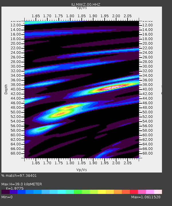
| Estimated Moho Depth: |
39.0 km |
| Estimated Crust Vp/Vs: |
1.98 |
| Assumed Crust Vp: |
6.571 km/s |
| Estimated Crust Vs: |
3.323 km/s |
| Estimated Crust Poisson's Ratio: |
0.33 |
|
| Radial Match: |
97.36401 % |
| Radial Bump: |
324 |
| Transverse Match: |
93.7102 % |
| Transverse Bump: |
400 |
| SOD ConfigId: |
512894 |
| Insert Time: |
2013-09-13 02:19:51.874 +0000 |
| GWidth: |
2.5 |
| Max Bumps: |
400 |
| Tol: |
0.001 |
|

Signal To Noise
| Channel | StoN | STA | LTA |
| IU:MAKZ:00:HHZ:20130406T04:53:12.52803Z | 66.0601 | 3.1219029E-6 | 4.7258524E-8 |
| IU:MAKZ:00:HH1:20130406T04:53:12.52803Z | 17.644497 | 5.1974354E-7 | 2.9456409E-8 |
| IU:MAKZ:00:HH2:20130406T04:53:12.52803Z | 28.158796 | 1.1547667E-6 | 4.1009095E-8 |
| Arrivals |
| Ps | 6.0 SECOND |
| PpPs | 17 SECOND |
| PsPs/PpSs | 23 SECOND |


