You are here: Home > Network List > UW - Pacific Northwest Regional Seismic Network Stations List
> Station LEBA Lebam, WA, USA > Earthquake Result Viewer
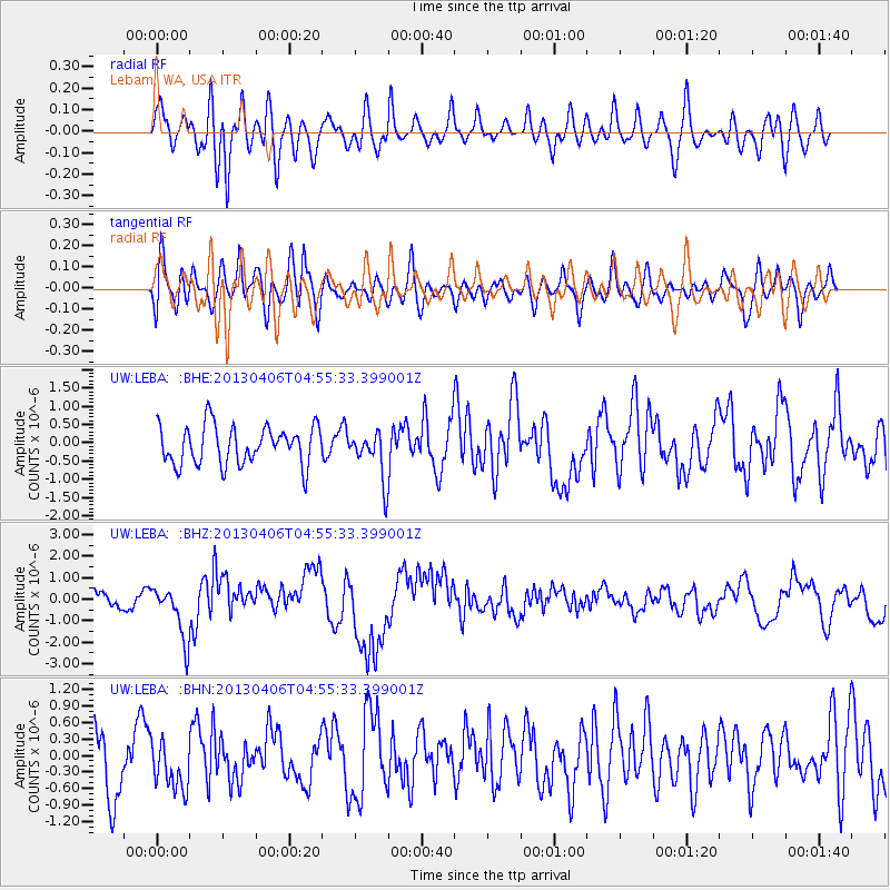
LEBA Lebam, WA, USA - Earthquake Result Viewer
*The percent match for this event was below the threshold and hence no stack was calculated.
| Earthquake location: |
Irian Jaya, Indonesia |
| Earthquake latitude/longitude: |
-3.5/138.5 |
| Earthquake time(UTC): |
2013/04/06 (096) 04:42:35 GMT |
| Earthquake Depth: |
66 km |
| Earthquake Magnitude: |
7.0 MW, 6.6 MB, 7.0 MW |
| Earthquake Catalog/Contributor: |
NEIC PDE/NEIC PDE-W |
|
| Network: |
UW Pacific Northwest Regional Seismic Network |
| Station: |
LEBA Lebam, WA, USA |
| Lat/Lon: |
46.55 N/123.56 W |
| Elevation: |
73 m |
|
| Distance: |
98.0 deg |
| Az: |
43.654 deg |
| Baz: |
273.356 deg |
| Ray Param: |
$rayparam |
*The percent match for this event was below the threshold and hence was not used in the summary stack. |
|
| Radial Match: |
60.47135 % |
| Radial Bump: |
400 |
| Transverse Match: |
61.56728 % |
| Transverse Bump: |
400 |
| SOD ConfigId: |
512894 |
| Insert Time: |
2013-09-13 02:24:23.472 +0000 |
| GWidth: |
2.5 |
| Max Bumps: |
400 |
| Tol: |
0.001 |
|
Signal To Noise
| Channel | StoN | STA | LTA |
| UW:LEBA: :BHZ:20130406T04:55:33.399001Z | 3.2434413 | 1.2425337E-6 | 3.8309116E-7 |
| UW:LEBA: :BHN:20130406T04:55:33.399001Z | 0.69809806 | 4.6831335E-7 | 6.7084176E-7 |
| UW:LEBA: :BHE:20130406T04:55:33.399001Z | 1.2389027 | 6.5594014E-7 | 5.294525E-7 |
| Arrivals |
| Ps | |
| PpPs | |
| PsPs/PpSs | |


