You are here: Home > Network List > TA - USArray Transportable Network (new EarthScope stations) Stations List
> Station V49A McMinnville, TN, USA > Earthquake Result Viewer
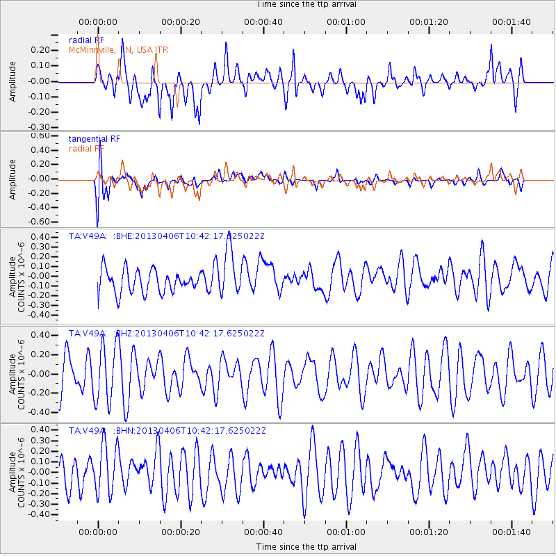
V49A McMinnville, TN, USA - Earthquake Result Viewer
*The percent match for this event was below the threshold and hence no stack was calculated.
| Earthquake location: |
Southern East Pacific Rise |
| Earthquake latitude/longitude: |
-55.6/-123.2 |
| Earthquake time(UTC): |
2013/04/06 (096) 10:29:20 GMT |
| Earthquake Depth: |
9.9 km |
| Earthquake Magnitude: |
5.5 MW |
| Earthquake Catalog/Contributor: |
NEIC PDE/NEIC PDE-W |
|
| Network: |
TA USArray Transportable Network (new EarthScope stations) |
| Station: |
V49A McMinnville, TN, USA |
| Lat/Lon: |
35.77 N/85.90 W |
| Elevation: |
329 m |
|
| Distance: |
96.5 deg |
| Az: |
29.737 deg |
| Baz: |
200.235 deg |
| Ray Param: |
$rayparam |
*The percent match for this event was below the threshold and hence was not used in the summary stack. |
|
| Radial Match: |
53.474487 % |
| Radial Bump: |
400 |
| Transverse Match: |
63.008434 % |
| Transverse Bump: |
400 |
| SOD ConfigId: |
512894 |
| Insert Time: |
2013-09-13 02:44:49.986 +0000 |
| GWidth: |
2.5 |
| Max Bumps: |
400 |
| Tol: |
0.001 |
|
Signal To Noise
| Channel | StoN | STA | LTA |
| TA:V49A: :BHZ:20130406T10:42:17.625022Z | 1.5674 | 3.0094506E-7 | 1.9200272E-7 |
| TA:V49A: :BHN:20130406T10:42:17.625022Z | 2.0026596 | 2.4617063E-7 | 1.2292186E-7 |
| TA:V49A: :BHE:20130406T10:42:17.625022Z | 2.1781301 | 2.4903588E-7 | 1.143347E-7 |
| Arrivals |
| Ps | |
| PpPs | |
| PsPs/PpSs | |


