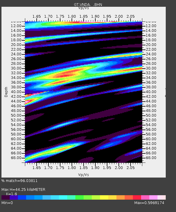
VNDA Wright Valley (Bull Pass) Antarctica - Earthquake Result Viewer
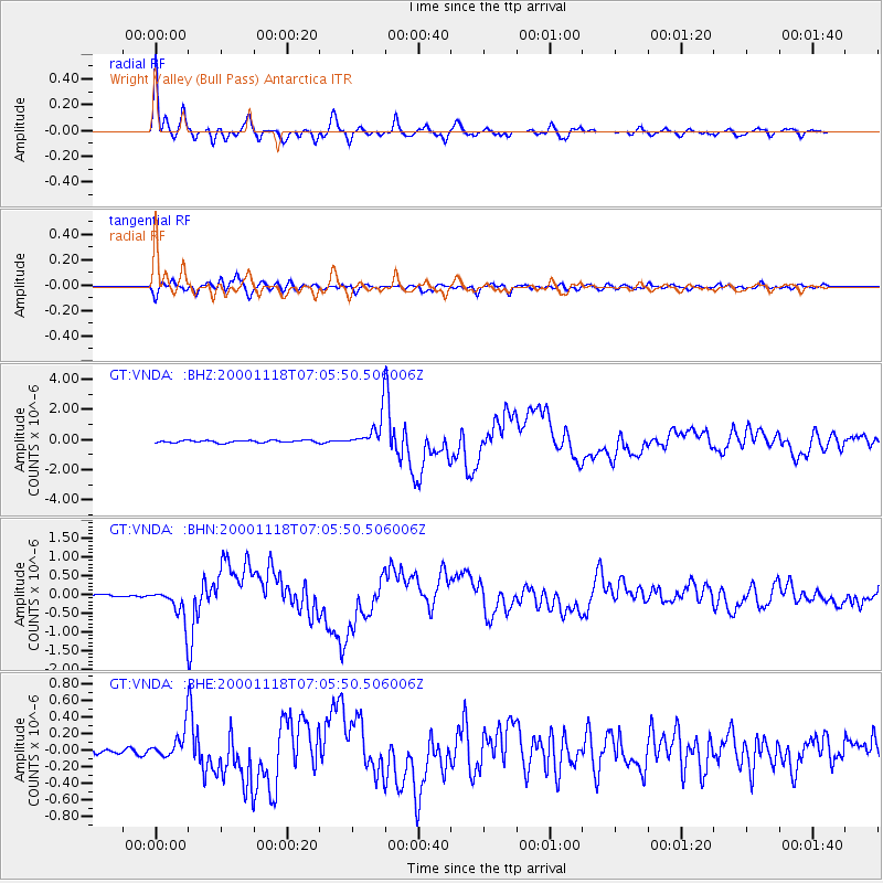
Earthquake location: New Britain Region, P.N.G.
Earthquake latitude/longitude: -5.2/151.8
Earthquake time(UTC): 2000/11/18 (323) 06:54:58 GMT
Earthquake Depth: 33 km
Earthquake Magnitude: 6.2 MB, 6.6 MS, 6.8 MW, 6.8 MW
Earthquake Catalog/Contributor: WHDF/NEIC
Network: GT Global Telemetered Seismograph Network (USAF/USGS)
Station: VNDA Wright Valley (Bull Pass) Antarctica
Lat/Lon: 77.52 S/161.85 E
Elevation: 151 m
Distance: 72.4 deg
Az: 177.711 deg
Baz: 349.464 deg
Ray Param: 0.053608123
Estimated Moho Depth: 44.25 km
Estimated Crust Vp/Vs: 1.60
Assumed Crust Vp: 6.245 km/s
Estimated Crust Vs: 3.903 km/s
Estimated Crust Poisson's Ratio: 0.18
Radial Match: 96.03811 %
Radial Bump: 400
Transverse Match: 88.04285 %
Transverse Bump: 400
SOD ConfigId: 3744
Insert Time: 2010-02-27 02:27:41.593 +0000
GWidth: 2.5
Max Bumps: 400
Tol: 0.001

Signal To Noise

ChannelStoNSTALTA
GT:VNDA: :BHN:20001118T07:05:50.506006Z10.0407014.5953965E-74.5767685E-8
GT:VNDA: :BHE:20001118T07:05:50.506006Z3.94508391.803393E-74.571241E-8
GT:VNDA: :BHZ:20001118T07:05:50.506006Z14.065441.054925E-67.500121E-8
Arrivals
Ps4.4 SECOND
PpPs18 SECOND
PsPs/PpSs22 SECOND