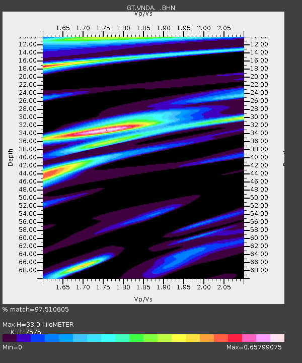
VNDA Wright Valley (Bull Pass) Antarctica - Earthquake Result Viewer
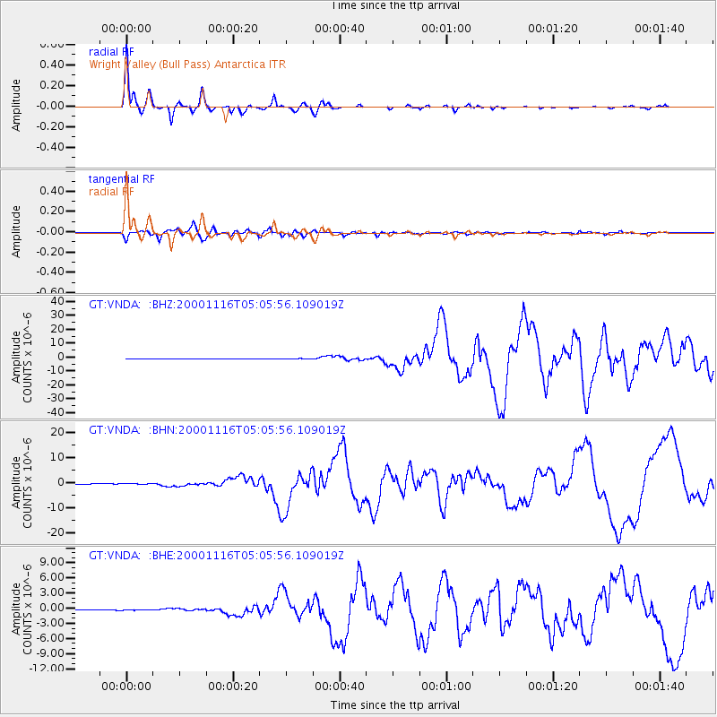
Earthquake location: New Ireland Region, P.N.G.
Earthquake latitude/longitude: -4.0/152.2
Earthquake time(UTC): 2000/11/16 (321) 04:54:56 GMT
Earthquake Depth: 33 km
Earthquake Magnitude: 6.0 MB, 8.2 MS, 8.0 MW, 8.0 ME
Earthquake Catalog/Contributor: WHDF/NEIC
Network: GT Global Telemetered Seismograph Network (USAF/USGS)
Station: VNDA Wright Valley (Bull Pass) Antarctica
Lat/Lon: 77.52 S/161.85 E
Elevation: 151 m
Distance: 73.7 deg
Az: 177.815 deg
Baz: 349.929 deg
Ray Param: 0.052803293
Estimated Moho Depth: 33.0 km
Estimated Crust Vp/Vs: 1.76
Assumed Crust Vp: 6.245 km/s
Estimated Crust Vs: 3.553 km/s
Estimated Crust Poisson's Ratio: 0.26
Radial Match: 97.510605 %
Radial Bump: 287
Transverse Match: 92.43196 %
Transverse Bump: 400
SOD ConfigId: 3744
Insert Time: 2010-02-27 02:27:46.421 +0000
GWidth: 2.5
Max Bumps: 400
Tol: 0.001

Signal To Noise

ChannelStoNSTALTA
GT:VNDA: :BHN:20001116T05:05:56.109019Z2.4867391.5717873E-76.320677E-8
GT:VNDA: :BHE:20001116T05:05:56.109019Z1.83775855.546341E-83.0179923E-8
GT:VNDA: :BHZ:20001116T05:05:56.109019Z2.47280622.7906222E-71.12852454E-7
Arrivals
Ps4.1 SECOND
PpPs14 SECOND
PsPs/PpSs18 SECOND