You are here: Home > Network List > AK - Alaska Regional Network Stations List
> Station WAT5 Susitna Watana 5, AK, USA > Earthquake Result Viewer
WAT5 Susitna Watana 5, AK, USA - Earthquake Result Viewer
| Earthquake location: |
Tonga Islands Region |
| Earthquake latitude/longitude: |
-22.0/-174.9 |
| Earthquake time(UTC): |
2014/07/16 (197) 10:58:32 GMT |
| Earthquake Depth: |
43 km |
| Earthquake Magnitude: |
5.6 MW |
| Earthquake Catalog/Contributor: |
ISC/ISC |
|
| Network: |
AK Alaska Regional Network |
| Station: |
WAT5 Susitna Watana 5, AK, USA |
| Lat/Lon: |
63.06 N/148.23 W |
| Elevation: |
1691 m |
|
| Distance: |
87.4 deg |
| Az: |
11.792 deg |
| Baz: |
204.602 deg |
| Ray Param: |
0.04329652 |
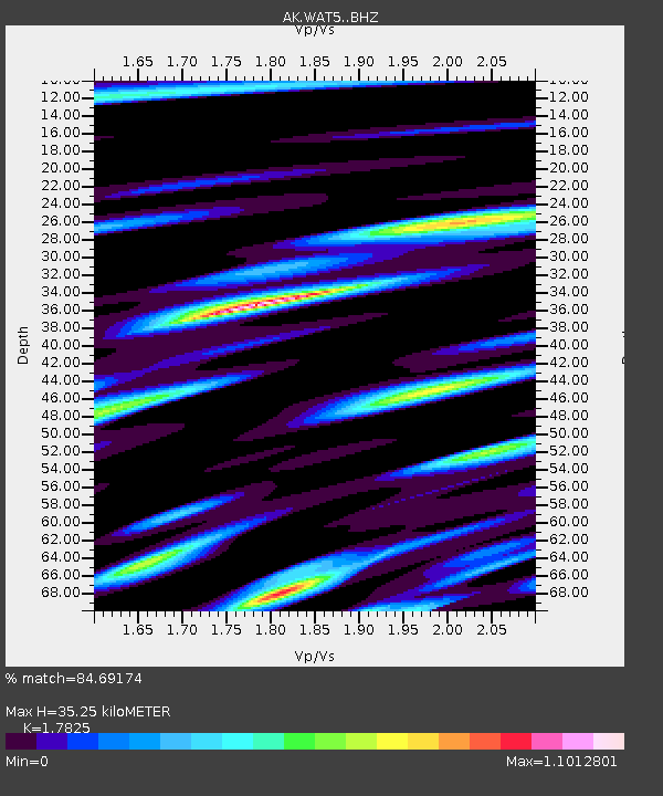
| Estimated Moho Depth: |
35.25 km |
| Estimated Crust Vp/Vs: |
1.78 |
| Assumed Crust Vp: |
6.566 km/s |
| Estimated Crust Vs: |
3.684 km/s |
| Estimated Crust Poisson's Ratio: |
0.27 |
|
| Radial Match: |
84.69174 % |
| Radial Bump: |
392 |
| Transverse Match: |
78.828575 % |
| Transverse Bump: |
382 |
| SOD ConfigId: |
3390531 |
| Insert Time: |
2019-04-12 21:39:29.069 +0000 |
| GWidth: |
2.5 |
| Max Bumps: |
400 |
| Tol: |
0.001 |
|

Signal To Noise
| Channel | StoN | STA | LTA |
| AK:WAT5: :BHZ:20140716T11:10:43.788Z | 8.747042 | 3.5415104E-7 | 4.0488093E-8 |
| AK:WAT5: :BHN:20140716T11:10:43.788Z | 2.9811888 | 1.9168185E-7 | 6.429712E-8 |
| AK:WAT5: :BHE:20140716T11:10:43.788Z | 3.8002553 | 1.4684358E-7 | 3.864045E-8 |
| Arrivals |
| Ps | 4.3 SECOND |
| PpPs | 15 SECOND |
| PsPs/PpSs | 19 SECOND |


