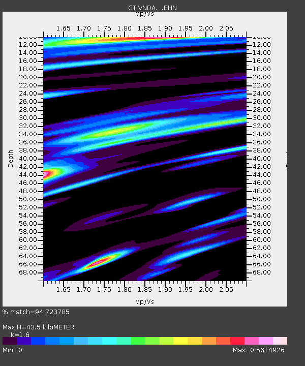
VNDA Wright Valley (Bull Pass) Antarctica - Earthquake Result Viewer
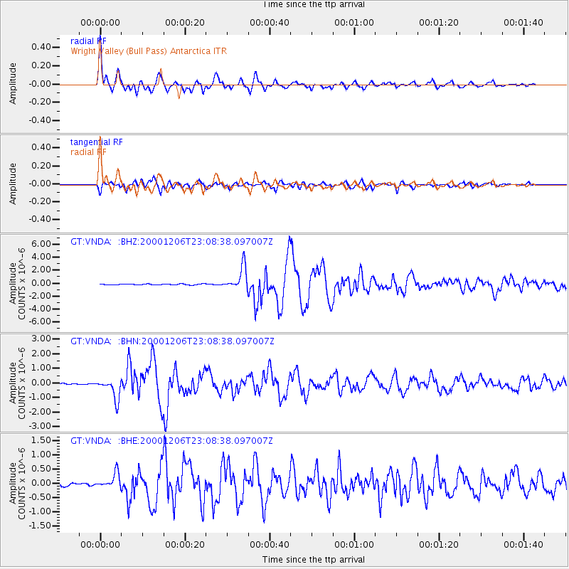
Earthquake location: New Britain Region, P.N.G.
Earthquake latitude/longitude: -4.2/152.7
Earthquake time(UTC): 2000/12/06 (341) 22:57:40 GMT
Earthquake Depth: 31 km
Earthquake Magnitude: 6.1 MB, 6.6 MS, 6.6 MW, 6.2 ME
Earthquake Catalog/Contributor: WHDF/NEIC
Network: GT Global Telemetered Seismograph Network (USAF/USGS)
Station: VNDA Wright Valley (Bull Pass) Antarctica
Lat/Lon: 77.52 S/161.85 E
Elevation: 151 m
Distance: 73.4 deg
Az: 177.936 deg
Baz: 350.498 deg
Ray Param: 0.052978687
Estimated Moho Depth: 43.5 km
Estimated Crust Vp/Vs: 1.60
Assumed Crust Vp: 6.245 km/s
Estimated Crust Vs: 3.903 km/s
Estimated Crust Poisson's Ratio: 0.18
Radial Match: 94.723785 %
Radial Bump: 400
Transverse Match: 89.425644 %
Transverse Bump: 400
SOD ConfigId: 3744
Insert Time: 2010-02-27 02:28:06.388 +0000
GWidth: 2.5
Max Bumps: 400
Tol: 0.001

Signal To Noise

ChannelStoNSTALTA
GT:VNDA: :BHN:20001206T23:08:38.097007Z13.6027667.320352E-75.381517E-8
GT:VNDA: :BHE:20001206T23:08:38.097007Z4.06931642.7159368E-76.674185E-8
GT:VNDA: :BHZ:20001206T23:08:38.097007Z26.1536431.8257873E-66.9810056E-8
Arrivals
Ps4.3 SECOND
PpPs17 SECOND
PsPs/PpSs22 SECOND