You are here: Home > Network List > TA - USArray Transportable Network (new EarthScope stations) Stations List
> Station 833A Chaparral WMA, Artesia Wells, TX, USA > Earthquake Result Viewer
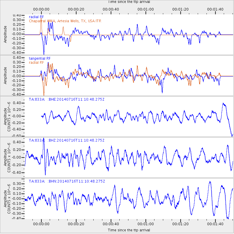
833A Chaparral WMA, Artesia Wells, TX, USA - Earthquake Result Viewer
*The percent match for this event was below the threshold and hence no stack was calculated.
| Earthquake location: |
Tonga Islands Region |
| Earthquake latitude/longitude: |
-22.0/-174.9 |
| Earthquake time(UTC): |
2014/07/16 (197) 10:58:32 GMT |
| Earthquake Depth: |
43 km |
| Earthquake Magnitude: |
5.6 MW |
| Earthquake Catalog/Contributor: |
ISC/ISC |
|
| Network: |
TA USArray Transportable Network (new EarthScope stations) |
| Station: |
833A Chaparral WMA, Artesia Wells, TX, USA |
| Lat/Lon: |
28.32 N/99.39 W |
| Elevation: |
171 m |
|
| Distance: |
88.3 deg |
| Az: |
58.623 deg |
| Baz: |
243.96 deg |
| Ray Param: |
$rayparam |
*The percent match for this event was below the threshold and hence was not used in the summary stack. |
|
| Radial Match: |
72.1336 % |
| Radial Bump: |
400 |
| Transverse Match: |
63.3134 % |
| Transverse Bump: |
400 |
| SOD ConfigId: |
3390531 |
| Insert Time: |
2019-04-12 21:43:13.752 +0000 |
| GWidth: |
2.5 |
| Max Bumps: |
400 |
| Tol: |
0.001 |
|
Signal To Noise
| Channel | StoN | STA | LTA |
| TA:833A: :BHZ:20140716T11:10:48.275Z | 1.5714328 | 2.2647508E-7 | 1.4412012E-7 |
| TA:833A: :BHN:20140716T11:10:48.275Z | 0.8423744 | 6.122129E-8 | 7.267706E-8 |
| TA:833A: :BHE:20140716T11:10:48.275Z | 0.7085487 | 8.363214E-8 | 1.18033E-7 |
| Arrivals |
| Ps | |
| PpPs | |
| PsPs/PpSs | |


