You are here: Home > Network List > TA - USArray Transportable Network (new EarthScope stations) Stations List
> Station M04C Macdoel, CA, USA > Earthquake Result Viewer
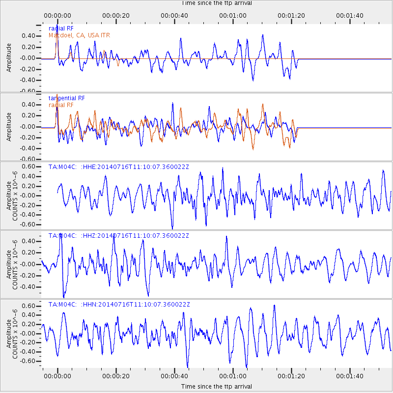
M04C Macdoel, CA, USA - Earthquake Result Viewer
*The percent match for this event was below the threshold and hence no stack was calculated.
| Earthquake location: |
Tonga Islands Region |
| Earthquake latitude/longitude: |
-22.0/-174.9 |
| Earthquake time(UTC): |
2014/07/16 (197) 10:58:32 GMT |
| Earthquake Depth: |
43 km |
| Earthquake Magnitude: |
5.6 MW |
| Earthquake Catalog/Contributor: |
ISC/ISC |
|
| Network: |
TA USArray Transportable Network (new EarthScope stations) |
| Station: |
M04C Macdoel, CA, USA |
| Lat/Lon: |
41.78 N/121.84 W |
| Elevation: |
1391 m |
|
| Distance: |
80.2 deg |
| Az: |
37.319 deg |
| Baz: |
228.771 deg |
| Ray Param: |
$rayparam |
*The percent match for this event was below the threshold and hence was not used in the summary stack. |
|
| Radial Match: |
68.13667 % |
| Radial Bump: |
400 |
| Transverse Match: |
44.40137 % |
| Transverse Bump: |
400 |
| SOD ConfigId: |
3390531 |
| Insert Time: |
2019-04-12 21:43:29.200 +0000 |
| GWidth: |
2.5 |
| Max Bumps: |
400 |
| Tol: |
0.001 |
|
Signal To Noise
| Channel | StoN | STA | LTA |
| TA:M04C: :HHZ:20140716T11:10:07.360022Z | 2.5234208 | 3.1305737E-7 | 1.240607E-7 |
| TA:M04C: :HHN:20140716T11:10:07.360022Z | 1.6163235 | 2.9302788E-7 | 1.8129283E-7 |
| TA:M04C: :HHE:20140716T11:10:07.360022Z | 0.9163563 | 1.5953367E-7 | 1.7409566E-7 |
| Arrivals |
| Ps | |
| PpPs | |
| PsPs/PpSs | |


