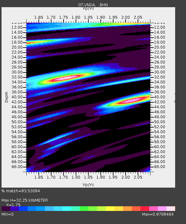
VNDA Wright Valley (Bull Pass) Antarctica - Earthquake Result Viewer
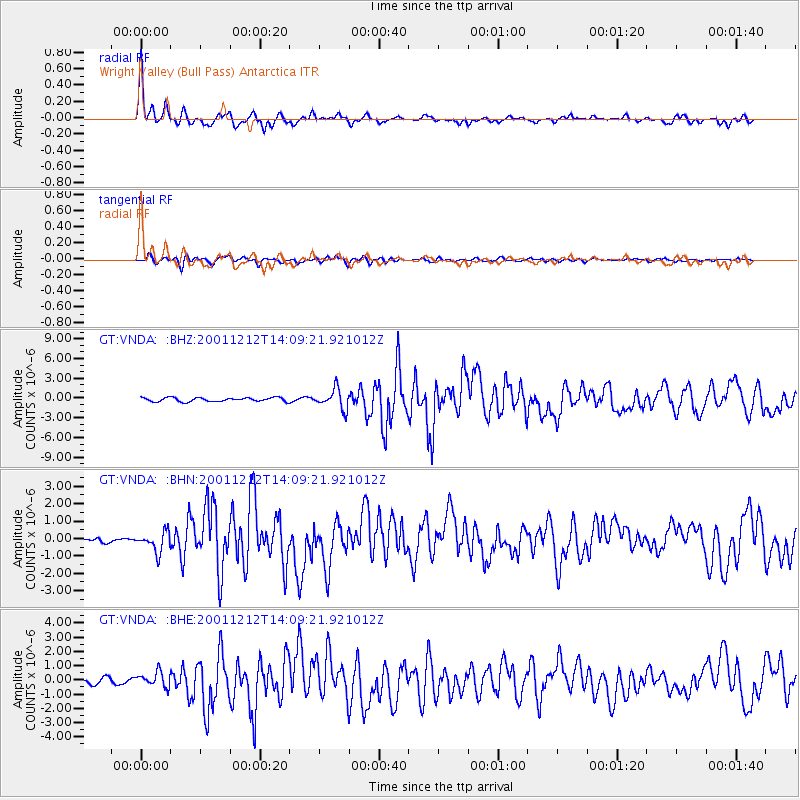
Earthquake location: South Of Australia
Earthquake latitude/longitude: -42.8/124.7
Earthquake time(UTC): 2001/12/12 (346) 14:02:35 GMT
Earthquake Depth: 10 km
Earthquake Magnitude: 6.5 MB, 6.7 MS, 7.1 MW, 7.0 MW
Earthquake Catalog/Contributor: WHDF/NEIC
Network: GT Global Telemetered Seismograph Network (USAF/USGS)
Station: VNDA Wright Valley (Bull Pass) Antarctica
Lat/Lon: 77.52 S/161.85 E
Elevation: 151 m
Distance: 38.0 deg
Az: 167.663 deg
Baz: 313.717 deg
Ray Param: 0.07584119
Estimated Moho Depth: 32.25 km
Estimated Crust Vp/Vs: 1.75
Assumed Crust Vp: 6.245 km/s
Estimated Crust Vs: 3.568 km/s
Estimated Crust Poisson's Ratio: 0.26
Radial Match: 93.53094 %
Radial Bump: 293
Transverse Match: 81.606735 %
Transverse Bump: 400
SOD ConfigId: 20082
Insert Time: 2010-02-27 02:28:41.494 +0000
GWidth: 2.5
Max Bumps: 400
Tol: 0.001

Signal To Noise

ChannelStoNSTALTA
GT:VNDA: :BHN:20011212T14:09:21.921012Z3.41579375.752213E-71.6840048E-7
GT:VNDA: :BHE:20011212T14:09:21.921012Z3.4773215.1697026E-71.4866913E-7
GT:VNDA: :BHZ:20011212T14:09:21.921012Z5.1604021.5102297E-62.926574E-7
Arrivals
Ps4.2 SECOND
PpPs13 SECOND
PsPs/PpSs17 SECOND