You are here: Home > Network List > TA - USArray Transportable Network (new EarthScope stations) Stations List
> Station M52A Chesterland, OH, USA > Earthquake Result Viewer
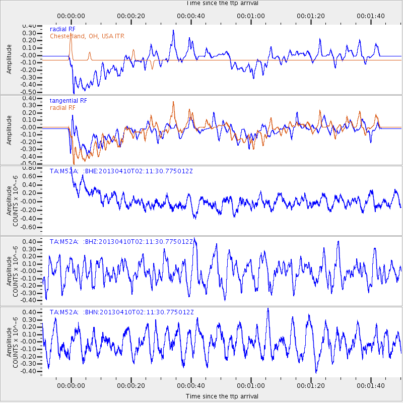
M52A Chesterland, OH, USA - Earthquake Result Viewer
*The percent match for this event was below the threshold and hence no stack was calculated.
| Earthquake location: |
Southern Iran |
| Earthquake latitude/longitude: |
28.4/51.6 |
| Earthquake time(UTC): |
2013/04/10 (100) 01:58:27 GMT |
| Earthquake Depth: |
15 km |
| Earthquake Magnitude: |
5.6 MB |
| Earthquake Catalog/Contributor: |
NEIC PDE/NEIC PDE-W |
|
| Network: |
TA USArray Transportable Network (new EarthScope stations) |
| Station: |
M52A Chesterland, OH, USA |
| Lat/Lon: |
41.54 N/81.36 W |
| Elevation: |
382 m |
|
| Distance: |
98.0 deg |
| Az: |
326.317 deg |
| Baz: |
40.627 deg |
| Ray Param: |
$rayparam |
*The percent match for this event was below the threshold and hence was not used in the summary stack. |
|
| Radial Match: |
58.637383 % |
| Radial Bump: |
400 |
| Transverse Match: |
58.196945 % |
| Transverse Bump: |
400 |
| SOD ConfigId: |
512894 |
| Insert Time: |
2013-09-13 03:42:30.587 +0000 |
| GWidth: |
2.5 |
| Max Bumps: |
400 |
| Tol: |
0.001 |
|
Signal To Noise
| Channel | StoN | STA | LTA |
| TA:M52A: :BHZ:20130410T02:11:30.775012Z | 0.7670368 | 1.2580327E-7 | 1.6401204E-7 |
| TA:M52A: :BHN:20130410T02:11:30.775012Z | 1.088024 | 1.6760455E-7 | 1.5404491E-7 |
| TA:M52A: :BHE:20130410T02:11:30.775012Z | 1.1227144 | 2.2169259E-7 | 1.9746123E-7 |
| Arrivals |
| Ps | |
| PpPs | |
| PsPs/PpSs | |


