You are here: Home > Network List > UW - Pacific Northwest Regional Seismic Network Stations List
> Station LEBA Lebam, WA, USA > Earthquake Result Viewer
LEBA Lebam, WA, USA - Earthquake Result Viewer
*The percent match for this event was below the threshold and hence no stack was calculated.
| Earthquake location: |
Tonga Islands Region |
| Earthquake latitude/longitude: |
-22.0/-174.9 |
| Earthquake time(UTC): |
2014/07/16 (197) 10:58:32 GMT |
| Earthquake Depth: |
43 km |
| Earthquake Magnitude: |
5.6 MW |
| Earthquake Catalog/Contributor: |
ISC/ISC |
|
| Network: |
UW Pacific Northwest Regional Seismic Network |
| Station: |
LEBA Lebam, WA, USA |
| Lat/Lon: |
46.55 N/123.56 W |
| Elevation: |
73 m |
|
| Distance: |
82.5 deg |
| Az: |
32.907 deg |
| Baz: |
226.91 deg |
| Ray Param: |
$rayparam |
*The percent match for this event was below the threshold and hence was not used in the summary stack. |
|
| Radial Match: |
60.431763 % |
| Radial Bump: |
400 |
| Transverse Match: |
67.17345 % |
| Transverse Bump: |
392 |
| SOD ConfigId: |
3390531 |
| Insert Time: |
2019-04-12 21:44:43.459 +0000 |
| GWidth: |
2.5 |
| Max Bumps: |
400 |
| Tol: |
0.001 |
|
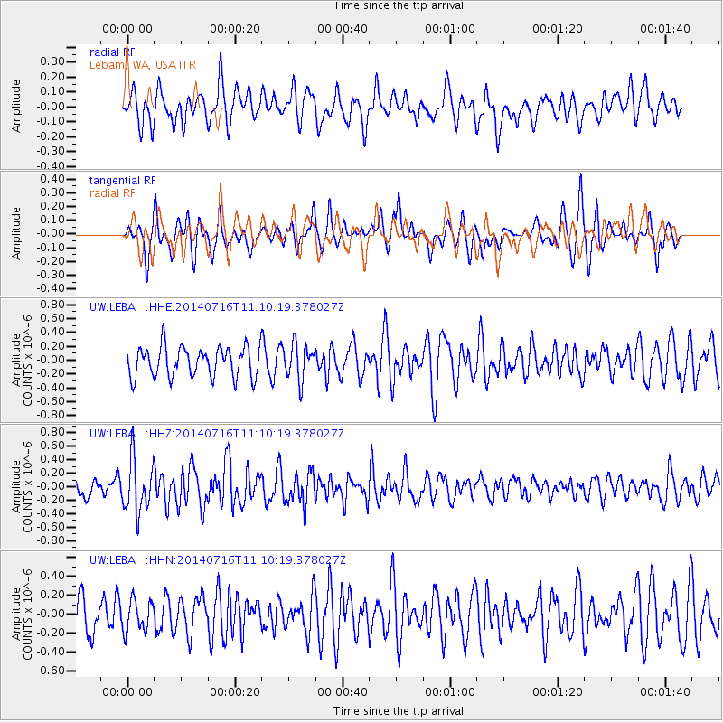
Signal To Noise
| Channel | StoN | STA | LTA |
| UW:LEBA: :HHZ:20140716T11:10:19.378027Z | 2.4154334 | 3.9133528E-7 | 1.6201453E-7 |
| UW:LEBA: :HHN:20140716T11:10:19.378027Z | 0.7037041 | 1.638519E-7 | 2.3284201E-7 |
| UW:LEBA: :HHE:20140716T11:10:19.378027Z | 1.1855909 | 2.5609435E-7 | 2.1600567E-7 |
| Arrivals |
| Ps | |
| PpPs | |
| PsPs/PpSs | |


