You are here: Home > Network List > UW - Pacific Northwest Regional Seismic Network Stations List
> Station MRBL Marblemount, WA, USA > Earthquake Result Viewer
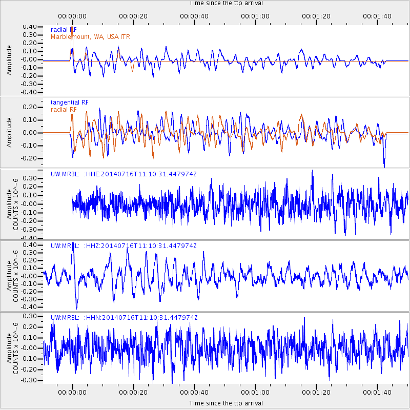
MRBL Marblemount, WA, USA - Earthquake Result Viewer
*The percent match for this event was below the threshold and hence no stack was calculated.
| Earthquake location: |
Tonga Islands Region |
| Earthquake latitude/longitude: |
-22.0/-174.9 |
| Earthquake time(UTC): |
2014/07/16 (197) 10:58:32 GMT |
| Earthquake Depth: |
43 km |
| Earthquake Magnitude: |
5.6 MW |
| Earthquake Catalog/Contributor: |
ISC/ISC |
|
| Network: |
UW Pacific Northwest Regional Seismic Network |
| Station: |
MRBL Marblemount, WA, USA |
| Lat/Lon: |
48.52 N/121.48 W |
| Elevation: |
75 m |
|
| Distance: |
84.9 deg |
| Az: |
32.394 deg |
| Baz: |
228.383 deg |
| Ray Param: |
$rayparam |
*The percent match for this event was below the threshold and hence was not used in the summary stack. |
|
| Radial Match: |
55.91203 % |
| Radial Bump: |
400 |
| Transverse Match: |
58.68673 % |
| Transverse Bump: |
400 |
| SOD ConfigId: |
3390531 |
| Insert Time: |
2019-04-12 21:44:46.273 +0000 |
| GWidth: |
2.5 |
| Max Bumps: |
400 |
| Tol: |
0.001 |
|
Signal To Noise
| Channel | StoN | STA | LTA |
| UW:MRBL: :HHZ:20140716T11:10:31.447974Z | 3.1384676 | 2.0019637E-7 | 6.378794E-8 |
| UW:MRBL: :HHN:20140716T11:10:31.447974Z | 1.0743188 | 1.002879E-7 | 9.335023E-8 |
| UW:MRBL: :HHE:20140716T11:10:31.447974Z | 1.1959126 | 9.4879276E-8 | 7.9336296E-8 |
| Arrivals |
| Ps | |
| PpPs | |
| PsPs/PpSs | |


